IMAGES TAKEN NEAR TO
Redshank Walk, NEWPORT, NP19 4BW
Introduction
This page details the photographs taken nearby to Redshank Walk, NP19 4BW by members of the Geograph project.
The Geograph project started in 2005 with the aim of publishing, organising and preserving representative images for every square kilometre of Great Britain, Ireland and the Isle of Man.

There are currently over 7.5m images from over14,400 individuals and you can help contribute to the project by visiting https://www.geograph.org.uk
Image Map
Images are licensed for reuse under creativecommons.org/licenses/by-sa/2.0
Notes
- Clicking on the map will re-center to the selected point.
- The higher the marker number, the further away the image location is from the centre of the postcode.
Image Listing (114 Images Found)
Images are licensed for reuse under creativecommons.org/licenses/by-sa/2.0
Image
Details
Distance
1
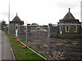
Former entrance to Orb Works, Corporation Road, Newport
Located at the northeast end of Orb Works. This part of the site is to be redeveloped, mainly with housing. The entrance to the Works is now at the other
end of the site, at the far end of Stephenson Street, http://www.geograph.org.uk/photo/1624913 close to the Transporter Bridge.
Image: © Jaggery
Taken: 18 Dec 2009
0.04 miles
2

Site of Orb steelworks
The full site of Orb steelworks occupies 74 acres. This 22 acre portion has been cleared for the creation of a housing development to be named Lysaght Village.
John Lysaght of Wolverhampton established a steelworks on this site in 1898 and in its heyday it employed over 3000 people.
In the background is the City Bridge http://www.geograph.org.uk/photo/1140452 .
Image: © Robin Drayton
Taken: 9 Dec 2009
0.05 miles
3

Clarke Road, Lysaght Village, Newport
Viewed from Lysaght Way in early May 2014. Clarke Road and its houses are recent additions to the Taylor Wimpey housing development on land formerly in the NE corner of the Tata Steel Orb steelworks site (originally Lysaght Orb steelworks). The small building on the left (black door) is a GTC electricity substation, identifier N0011635 LYSAGHT VILLAGE.
Image: © Jaggery
Taken: 5 May 2014
0.05 miles
4

Lysaght Village, Newport
A Taylor Wimpey development on the right bank of the river Usk.
Image: © Eirian Evans
Taken: 23 Jul 2015
0.05 miles
5

Former entrance to Orb steelworks
22 acres of the Orb Steelworks site is being levelled in preparation for a new housing development.
It appears that this distinctive entrance gateway is being retained.
See also Image
Image: © Robin Drayton
Taken: 9 Dec 2009
0.05 miles
6

Lysaght Village banner, Newport
Viewed across Corporation Road. The Taylor Wimpey banner is at the former entrance to Orb Works. This NE part of the site is being redeveloped, mainly with housing. The Orb Works entrance is now at the other end of the site, at the far end of Stephenson Street, http://www.geograph.org.uk/photo/1624913 close to the Transporter Bridge.
Image: © Jaggery
Taken: 11 Jan 2013
0.06 miles
7

Dry mortar silos, Lysaght Village, Newport
Viewed across Corporation Road near a former entrance http://www.geograph.org.uk/photo/3330341 to Orb Works.
This part of the Orb site is a Taylor Wimpey new housing development known as Lysaght Village.
Image: © Jaggery
Taken: 11 Jan 2013
0.06 miles
9

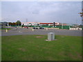
Construction site beside the River Usk, Newport
The final section of this large Taylor Wimpey development is now being completed.
See this http://www.geograph.org.uk/photo/1621101 for some history of this site.
Newport Transporter Bridge is in the distance.
Image: © Robin Drayton
Taken: 3 Nov 2016
0.09 miles
10
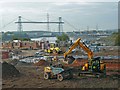
Construction site, Newport
The final section of this large Taylor Wimpey development is now being completed.
See this http://www.geograph.org.uk/photo/1621101 for some history of this site.
The River Usk and Newport Transporter Bridge are in the distance.
Image: © Robin Drayton
Taken: 3 Nov 2016
0.09 miles