1
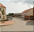
Lysaght Circle, Lysaght Village, Newport
Recently-built houses on the Taylor Wimpey housing development on land formerly
in the NE corner of the Tata Steel Orb steelworks site (originally Lysaght Orb steelworks).
Image: © Jaggery
Taken: 5 May 2014
0.03 miles
2
Corner of Lysaght Way and Lysaght Avenue, Newport
Viewed across Lysaght Way. The newly-built housing is in Lysaght Village. http://www.geograph.org.uk/photo/2539967
Image: © Jaggery
Taken: 5 Aug 2011
0.07 miles
3
Construction site entrance, Lysaght Village, Newport
The large Taylor Wimpey notice is at the entrance to the site. http://www.geograph.org.uk/photo/2540069
Among the various statements and warnings is "Remember: no safety helmet, no safety boots, no high visibility vests, no safety training = no job".
Image: © Jaggery
Taken: 5 Aug 2011
0.07 miles
4
Dividing line between houses and building site, Lysaght Village, Newport
The view is towards Corporation Road. Currently (early August 2011), Lysaght Way is the boundary between houses on the right and a fenced-off building site on the left.
Image: © Jaggery
Taken: 5 Aug 2011
0.07 miles
5
Lysaght Avenue, Lysaght Village, Newport
Newly-built houses in Lysaght Avenue, viewed from Lysaght Way. Lysaght Village occupies a site formerly part of Orb steelworks. http://www.geograph.org.uk/photo/1621101
Image: © Jaggery
Taken: 5 Aug 2011
0.07 miles
6
Lysaght Way, Lysaght Village, Newport
Newly-built houses viewed across Corporation Road. Lysaght Village occupies land http://www.geograph.org.uk/photo/1621101 formerly part of Orb steelworks.
Image: © Jaggery
Taken: 5 Aug 2011
0.07 miles
7
Building site, Lysaght Village, Newport
In early August 2011, there are houses http://www.geograph.org.uk/photo/2539972 on the west side of the Lysaght Village site whereas the eastern side is a building site.
Image: © Jaggery
Taken: 5 Aug 2011
0.10 miles
8
Far end of Lysaght Way, Lysaght Village, Newport
Viewed from the edge of Lysaght Way. The housing is in a section of Lysaght Village http://www.geograph.org.uk/photo/2539967 without, as yet (early August 2011), a street name sign. Newer houses at the left edge of the view do not yet have roofs.
Image: © Jaggery
Taken: 5 Aug 2011
0.10 miles
9
Old Dock Reach, River Usk
The wooden jetty on the east bank is next to the Orb steelworks which is to be mothballed.
Image: © M J Roscoe
Taken: 8 Feb 2020
0.13 miles
10
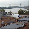
Construction site beside the River Usk, Newport
The final section of this large Taylor Wimpey development is now being completed.
See this http://www.geograph.org.uk/photo/1621101 for some history of this site.
Newport Transporter Bridge is in the distance.
Image: © Robin Drayton
Taken: 3 Nov 2016
0.13 miles


