IMAGES TAKEN NEAR TO
Maple Close, NEWPORT, NP19 0RF
Introduction
This page details the photographs taken nearby to Maple Close, NP19 0RF by members of the Geograph project.
The Geograph project started in 2005 with the aim of publishing, organising and preserving representative images for every square kilometre of Great Britain, Ireland and the Isle of Man.

There are currently over 7.5m images from over14,400 individuals and you can help contribute to the project by visiting https://www.geograph.org.uk
Image Map
Images are licensed for reuse under creativecommons.org/licenses/by-sa/2.0
Notes
- Clicking on the map will re-center to the selected point.
- The higher the marker number, the further away the image location is from the centre of the postcode.
Image Listing (89 Images Found)
Images are licensed for reuse under creativecommons.org/licenses/by-sa/2.0
Image
Details
Distance
1
Bleriot Close, Newport
Located at the SW corner of an area of housing on the south side of Somerton Road where street names have a 'pioneers of aviation' theme. Louis Blériot (1872–1936), a French aviator, made the first flight across a large body of water in a heavier-than-air craft when he crossed the English Channel in 1909.
Image: © Jaggery
Taken: 10 Aug 2011
0.02 miles
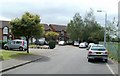
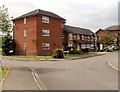
2
Recently-built houses in Orb Drive and St Andrew's Place, Newport
Looking south along Orb Drive past the right turn into St Andrew's Place.
Image: © Jaggery
Taken: 11 Jan 2013
0.05 miles
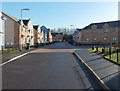
3
Orb Drive houses, Newport
Recently-built houses located between a Morrisons superstore behind the camera and a B&Q store http://www.geograph.org.uk/photo/1621542 ahead. Part of the B&Q is at the left edge of the view. This location is on the east side of Corporation Road.
Image: © Jaggery
Taken: 11 Jan 2013
0.05 miles
4
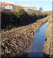
Drainage channel alongside B&Q store, Newport
Viewed from Orb Drive. The channel runs past the eastern edge of this http://www.geograph.org.uk/photo/1621542 Corporation Road B&Q.
Image: © Jaggery
Taken: 11 Jan 2013
0.07 miles
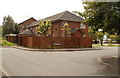
5
Brown Close, Newport
Located at the SE corner of an area of housing on the south side of Somerton Road where street names have a 'pioneers of aviation' theme. The close is named after Arthur Whitten Brown, who, together with John Alcock, piloted the first non-stop transatlantic flight, from Newfoundland to Ireland. The flight of 3,186 km (nearly 2,000 miles) in 1919 lasted 16 hours. Both men were knighted by King George V a few days later.
Image: © Jaggery
Taken: 10 Aug 2011
0.08 miles
6
Eastern side of Liswerry recreation area, Newport
Looking towards houses in Bleriot Close from a footpath http://www.geograph.org.uk/photo/2626365 along the edge of Liswerry Pill Reen.
Image: © Jaggery
Taken: 10 Aug 2011
0.08 miles
7
Alcock Close, Newport
Viewed from Kitty Hawk Drive. Alcock Close is part of an area of housing on the south side of Somerton Road where street names have a 'pioneers of aviation' theme. The close is named after John Alcock, who, together with Arthur Whitten Brown, piloted the first non-stop transatlantic flight, from Newfoundland to Ireland. The flight of 3,186 km (nearly 2,000 miles) in 1919 lasted 16 hours. Both men were knighted by King George V a few days later.
Image: © Jaggery
Taken: 10 Aug 2011
0.08 miles
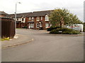
8
Corner of Kitty Hawk Drive and Lindbergh Close, Newport
Located in an area of housing on the south side of Somerton Road where street names have a 'pioneers of aviation' theme.
Kitty Hawk, a small town in North Carolina, became famous after the Wright brothers used a site 6km from the town to make their first controlled powered aeroplane flights on December 17, 1903.
Charles Lindbergh (1902-1974) achieved worldwide fame in 1927 after his solo non-stop flight from Long Island, New York to Le Bourget Field in Paris, a distance of nearly 3,600 statute miles (5,800 km), in the single-seat, single-engine monoplane Spirit of St. Louis.
Image: © Jaggery
Taken: 10 Aug 2011
0.11 miles
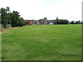
9
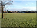
Liswerry Recreation Ground, Newport
Viewed from the footpath http://www.geograph.org.uk/photo/2199166 along the northern edge of the recreation ground, which measures about 250 metres by 130 metres, and contains three association football (soccer) pitches.
Image: © Jaggery
Taken: 15 Dec 2010
0.11 miles
10
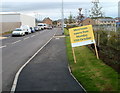
Orb Drive, Newport
Viewed from the Corporation Road end. Orb Drive is the newly-named road between a B&Q superstore http://www.geograph.org.uk/photo/1621542 on the left, and a Morrisons store http://www.geograph.org.uk/photo/2651729 on the right. This view was taken 15 minutes before the 9am official opening of the new Morrisons on Monday October 17th 2011.
Image: © Jaggery
Taken: 17 Oct 2011
0.12 miles