IMAGES TAKEN NEAR TO
Amelia Avenue, NEWPORT, NP19 0LS
Introduction
This page details the photographs taken nearby to Amelia Avenue, NP19 0LS by members of the Geograph project.
The Geograph project started in 2005 with the aim of publishing, organising and preserving representative images for every square kilometre of Great Britain, Ireland and the Isle of Man.

There are currently over 7.5m images from over14,400 individuals and you can help contribute to the project by visiting https://www.geograph.org.uk
Image Map
Images are licensed for reuse under creativecommons.org/licenses/by-sa/2.0
Notes
- Clicking on the map will re-center to the selected point.
- The higher the marker number, the further away the image location is from the centre of the postcode.
Image Listing (144 Images Found)
Images are licensed for reuse under creativecommons.org/licenses/by-sa/2.0
Image
Details
Distance
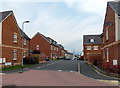
1
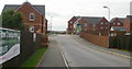
Amelia Avenue, Newport
Viewed from Corporation Road.
Image: © Jaggery
Taken: 23 Sep 2009
0.00 miles
2
Amelia Avenue, Newport
Looking along Amelia Avenue across Amelia Way.
Image: © Jaggery
Taken: 23 Sep 2009
0.00 miles
3
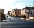
Amelia Avenue, Newport
Houses on the NW side of Amelia Avenue, viewed across Corporation Road.
Image: © Jaggery
Taken: 15 Dec 2010
0.00 miles
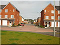
4
Amelia Avenue, Newport
Early 21st century houses viewed across Corporation Road.
Newport Transporter Bridge http://www.geograph.org.uk/photo/1624855 is in background.
Image: © Jaggery
Taken: 5 May 2014
0.01 miles
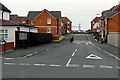
5
Amelia Close, Newport
Looking along Amelia Close from Amelia Avenue towards Portskewett Street. This is a through route for walkers and cyclists, but metal posts across the road ahead block access to Portskewett Street for cars and lorries.
Image: © Jaggery
Taken: 5 May 2014
0.05 miles
6
Gooner banners in Corporation Road, Newport
Fans of Arsenal Football Club often refer to themselves as Gooners, a name derived from the team's nickname, The Gunners.
Image: © Jaggery
Taken: 5 May 2014
0.05 miles
7
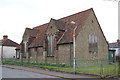
St Philip's Church in Newport
Image: © Adrian and Janet Quantock
Taken: 7 Apr 2006
0.06 miles
8
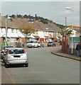
Jenkins Street, Newport
Viewed from Corporation Road.
Image: © Jaggery
Taken: 23 Sep 2009
0.06 miles
9
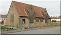
St Philips Church, Newport
Located on Jenkins Street, close to the Corporation Road junction.
To satisfy the immediate needs of a growing congregation in the area in the 1920s, an appeal was launched for funds to build a Sunday School close to Corporation Road School (as St Andrews School http://www.geograph.org.uk/photo/1621426 was known at the time). In July 1925, the new building was opened here in Jenkins Street, serving as parish hall and Sunday School. After serving in this capacity for 25 years, the building was, in July 1950, elevated to the status of a church (though still within the parish of St Andrew) and dedicated to St Philip, apostle and martyr.
The notice board outside the church at the date of the photo, September 2009,
shows that the church is now in Lliswerry parish.
Image: © Jaggery
Taken: 23 Sep 2009
0.06 miles
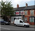
10
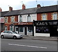
Wags hair studio, Newport
Wags hair & beauty studio is at 466 Corporation Road, opposite Oakley Street.
Bagini's (baguettes and sandwiches) is on the left.
Image: © Jaggery
Taken: 5 May 2014
0.06 miles