IMAGES TAKEN NEAR TO
Marshfield Street, NEWPORT, NP19 0GY
Introduction
This page details the photographs taken nearby to Marshfield Street, NP19 0GY by members of the Geograph project.
The Geograph project started in 2005 with the aim of publishing, organising and preserving representative images for every square kilometre of Great Britain, Ireland and the Isle of Man.

There are currently over 7.5m images from over14,400 individuals and you can help contribute to the project by visiting https://www.geograph.org.uk
Image Map
Images are licensed for reuse under creativecommons.org/licenses/by-sa/2.0
Notes
- Clicking on the map will re-center to the selected point.
- The higher the marker number, the further away the image location is from the centre of the postcode.
Image Listing (167 Images Found)
Images are licensed for reuse under creativecommons.org/licenses/by-sa/2.0
Image
Details
Distance
1
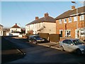
Colston Place, Newport
Viewed from near the corner of Colston Avenue. Colston Place is a short street connecting the NE ends of Colston Avenue and Marshfield Street. It also leads to Colston Court, behind the camera.
Image: © Jaggery
Taken: 15 Dec 2010
0.01 miles
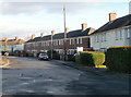
2
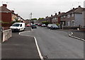
Turning circle half way along Colston Avenue, Newport
Located about 130 metres from both ends of the street.
Image: © Jaggery
Taken: 5 May 2014
0.05 miles
3
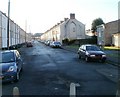
Newport : Magor Street viewed from the far end
Looking towards Corporation Road from the far end of the street. Formerly, there was vehicular access into Oliver Road, but this has been blocked off.
On the right are maisonettes, http://www.geograph.org.uk/photo/2198413 built many decades after the rest of the street. The appearance of the end of the terrace suggests that some terraced housing was demolished to make way for the maisonettes.
Image: © Jaggery
Taken: 15 Dec 2010
0.05 miles
4
Maisonettes, Magor Street, Newport
Modern maisonettes occupy the NW side of the far end of Magor Street. They were built many decades after the rest of the street. http://www.geograph.org.uk/photo/2198411
Image: © Jaggery
Taken: 15 Dec 2010
0.05 miles
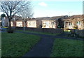
5
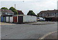
Six lockup garages, Colston Court, Newport
Viewed from the NE end of Colston Avenue.
Image: © Jaggery
Taken: 5 May 2014
0.06 miles
6
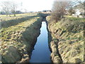
Liswerry Pill Reen, Newport
Looking towards Corporation Road from a footbridge. http://www.geograph.org.uk/photo/2199162 The reen (drainage channel) empties into the River Usk via Spytty Pill. The arched structure visible in the background is the City Bridge. http://www.geograph.org.uk/photo/557828
Image: © Jaggery
Taken: 15 Dec 2010
0.06 miles
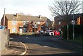
7
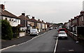
Colston Avenue, Newport
Viewed from the Corporation Road end.
Image: © Jaggery
Taken: 5 May 2014
0.06 miles
8
Oliver Road, Newport
Oliver Road heads away from Cromwell Road.
Were there Roundhead sympathisers on the Street Naming Committee when these names were chosen?
Image: © Jaggery
Taken: 28 Jan 2010
0.06 miles
9
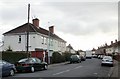
Southern end of Hampden Road, Newport
Houses on the east side of Hampden Road, viewed from the V-shaped bend connecting the road with Oliver Road. http://www.geograph.org.uk/photo/2198435
Image: © Jaggery
Taken: 15 Dec 2010
0.07 miles
10
Hampden Court, Newport
Hampden Court is a small cul-de-sac connecting with Hampden Road. http://www.geograph.org.uk/photo/2198423
Image: © Jaggery
Taken: 15 Dec 2010
0.07 miles