IMAGES TAKEN NEAR TO
Handsworth Street, NEWPORT, NP19 0FL
Introduction
This page details the photographs taken nearby to Handsworth Street, NP19 0FL by members of the Geograph project.
The Geograph project started in 2005 with the aim of publishing, organising and preserving representative images for every square kilometre of Great Britain, Ireland and the Isle of Man.

There are currently over 7.5m images from over14,400 individuals and you can help contribute to the project by visiting https://www.geograph.org.uk
Image Map
Images are licensed for reuse under creativecommons.org/licenses/by-sa/2.0
Notes
- Clicking on the map will re-center to the selected point.
- The higher the marker number, the further away the image location is from the centre of the postcode.
Image Listing (196 Images Found)
Images are licensed for reuse under creativecommons.org/licenses/by-sa/2.0
Image
Details
Distance
1
Gap in the houses in Dewstow Street, Newport
Number 5 Dewstow Street is on left of the fenced-off gap, number 13 on the right.
This was one row of houses until Luftwaffe bombing in August 1940 destroyed numbers 7, 9 and 11.
The gap remains today (May 2014).
Image: © Jaggery
Taken: 5 May 2014
0.03 miles
2
Row of 3 houses in Dewstow Street, Newport
Numbers 1,3 and 5 Dewstow Street were built as part of a longer row.
Numbers 7,9 and 11 were destroyed by Luftwaffe bombing in August 1940.
The gap http://www.geograph.org.uk/photo/3988920 remains today (May 2014).
Image: © Jaggery
Taken: 5 May 2014
0.03 miles
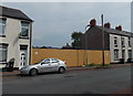
3
Fenced-off bombsite on the north side of Dewstow Street, Newport
Viewed in February 2020. Satellite images show extensive vegetation behind the fence on the site formerly occupied by 7, 9 and 11 Dewstow Street. The houses were destroyed by Luftwaffe bombing in August 1940.
Image: © Jaggery
Taken: 21 Feb 2020
0.03 miles
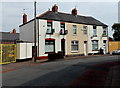
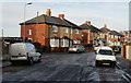
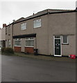
4
Row of houses, Bilston Street, Newport
The entrance https://www.geograph.org.uk/photo/6396785 to the yard of R C Scaffolding is on the right.
The house on the left side of the row is on the corner of Handsworth Street.
Image: © Jaggery
Taken: 21 Feb 2020
0.03 miles
5
Dewstow Street, Newport
Viewed from Corporation Road.
Image: © Jaggery
Taken: 23 Sep 2009
0.03 miles
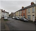
6
Hathaway Street, Newport
Houses on the west side of Hathaway Street, viewed from near the junction with Dewstow Street.
Image: © Jaggery
Taken: 24 Dec 2009
0.03 miles
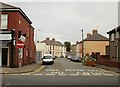
7
Towards a bend in Dewstow Street, Newport
Looking to the northeast from near the corner of Corporation Road.
Image: © Jaggery
Taken: 21 Feb 2020
0.03 miles
8
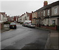
From Bilston Street towards Loftus Walk, Newport
Looking towards Loftus Walk, part of Loftus Garden Village, an area of houses built in the second decade of the 21st century. The houses in the foreground are many decades older.
Image: © Jaggery
Taken: 21 Feb 2020
0.03 miles
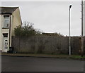
9
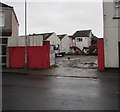
Entrance to R C Scaffolding yard, Bilston Street, Newport
The yard is set back from the east side of Bilston Street near the corner of Corporation Road.
Image: © Jaggery
Taken: 21 Feb 2020
0.04 miles
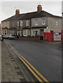
10
Former shop at a bend in Dewstow Street, Newport
The frontage suggests that this house is likely to be a converted former shop or other business premises.
Image: © Jaggery
Taken: 21 Feb 2020
0.04 miles