IMAGES TAKEN NEAR TO
Hammond Drive, NEWPORT, NP19 0EU
Introduction
This page details the photographs taken nearby to Hammond Drive, NP19 0EU by members of the Geograph project.
The Geograph project started in 2005 with the aim of publishing, organising and preserving representative images for every square kilometre of Great Britain, Ireland and the Isle of Man.

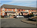
There are currently over 7.5m images from over14,400 individuals and you can help contribute to the project by visiting https://www.geograph.org.uk
Image Map
Images are licensed for reuse under creativecommons.org/licenses/by-sa/2.0
Notes
- Clicking on the map will re-center to the selected point.
- The higher the marker number, the further away the image location is from the centre of the postcode.
Image Listing (166 Images Found)
Images are licensed for reuse under creativecommons.org/licenses/by-sa/2.0
Image
Details
Distance
1
Fleetwood Close, Newport
Fleetwood Close connects with the far end of Lilburne Drive, between Ludlow Drive and the South Wales-London main railway line. The two parts of Fleetwood Close are at right angles to each other. This view is of houses on the west side of the close as it heads towards trees at the southern edge of the railway.
Image: © Jaggery
Taken: 28 Jan 2010
0.03 miles
2
Ludlow Close, Newport
Viewed from Lilburne Drive.
Image: © Jaggery
Taken: 28 Jan 2010
0.04 miles
3
Lilburne Drive, Newport
Viewed from the edge of Cromwell Road looking towards the left turn into Hammond Drive. The white triangles are painted on a speed bump.
Image: © Jaggery
Taken: 5 Jan 2013
0.04 miles
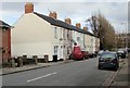
4
East along Dewstow Street, Newport
Towards Keene Street. The broken white line is at the Caldicot Street junction.
Image: © Jaggery
Taken: 21 Feb 2020
0.04 miles
5
Hammond Drive, Newport
Viewed from Keene Street.
Image: © Jaggery
Taken: 28 Jan 2010
0.05 miles
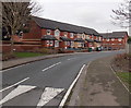
6
Lilburne Drive, Newport
Modern housing on the west side of Lilburne Drive, between Cromwell Road and Hammond Drive.
Image: © Jaggery
Taken: 28 Jan 2010
0.05 miles
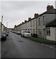
7
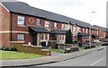
Ludlow Close houses, Newport
Houses on the south side of Ludlow Close, viewed from Lilburne Drive.
Image: © Jaggery
Taken: 28 Jan 2010
0.05 miles
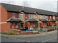
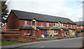
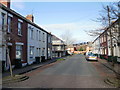
8
Henson Street houses, Newport
A block of terraced houses on the west side of Henson Street. Beyond the block, the northern half of the west side of Henson Street is lined with trees. http://www.geograph.org.uk/photo/1682312 Beyond the trees, the road bends in a horseshoe shape into Liscombe Street. http://www.geograph.org.uk/photo/1682327
Image: © Jaggery
Taken: 28 Jan 2010
0.05 miles
9
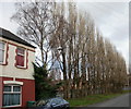
Henson Street trees, Newport
Trees line the northern half of the western side of Henson Street. Beyond the trees, the road bends to the right in a horseshoe shape into Liscombe Street. http://www.geograph.org.uk/photo/1682327
Image: © Jaggery
Taken: 28 Jan 2010
0.05 miles
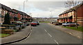
10
Keene Street, Newport
Looking north along Keene Street from the Cromwell Road end towards Hammond Drive.
Image: © Jaggery
Taken: 28 Jan 2010
0.06 miles