IMAGES TAKEN NEAR TO
Halstead Street, NEWPORT, NP19 0EL
Introduction
This page details the photographs taken nearby to Halstead Street, NP19 0EL by members of the Geograph project.
The Geograph project started in 2005 with the aim of publishing, organising and preserving representative images for every square kilometre of Great Britain, Ireland and the Isle of Man.

There are currently over 7.5m images from over14,400 individuals and you can help contribute to the project by visiting https://www.geograph.org.uk
Image Map
Images are licensed for reuse under creativecommons.org/licenses/by-sa/2.0
Notes
- Clicking on the map will re-center to the selected point.
- The higher the marker number, the further away the image location is from the centre of the postcode.
Image Listing (418 Images Found)
Images are licensed for reuse under creativecommons.org/licenses/by-sa/2.0
Image
Details
Distance
1
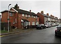
Gordon Street, Newport
Looking towards Vivian Road from the corner of Halstead Street.
Image: © Jaggery
Taken: 4 Jan 2010
0.01 miles
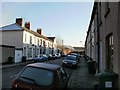
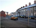
2
On-street parking, Halstead Street, Newport
Looking north from near the corner of Corporation Road in February 2020.
Image: © Jaggery
Taken: 21 Feb 2020
0.04 miles
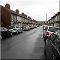
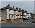
3
West side of Halstead Street, Newport
Viewed from the Corporation Road end looking towards the left turn for Essex Street.
Image: © Jaggery
Taken: 5 May 2014
0.04 miles
4
East along Essex Street, Newport
Towards Halstead Street.
Image: © Jaggery
Taken: 21 Feb 2020
0.04 miles
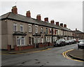
5
West side of Halstead Street, Newport
This part of Halstead Street is between Corporation Road and Essex Street (ahead).
Image: © Jaggery
Taken: 21 Feb 2020
0.04 miles
6
Lennard Street houses, Newport
Houses on the west side of the street, between Essex Street on the left and May Street ahead.
Image: © Jaggery
Taken: 5 May 2014
0.05 miles
7
Lennard Street towards May Street, Newport
Row of Lennard Street houses between Essex Street and May Street (ahead).
Image: © Jaggery
Taken: 21 Feb 2020
0.05 miles
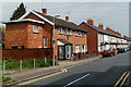
8
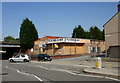
Floors-2-Go Wharf Road, Newport
Floors-2-Go got up and went. Their current premises http://www.geograph.org.uk/photo/3208939 are at the Maesglas Retail Park in the west of the city. This empty shop is on Wharf Road at the junction with Phillip Street.
Image: © Jaggery
Taken: 9 Aug 2009
0.06 miles
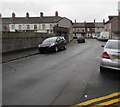
9
Phillip Street, Newport
Viewed from the corner of Wharf Road.
There is a contrast of housing on Phillip Street. On the right is terraced housing, probably late Victorian; on the left are modern houses http://www.geograph.org.uk/photo/1652531 , and beyond http://www.geograph.org.uk/photo/1652541 modern apartments.
Image: © Jaggery
Taken: 4 Jan 2010
0.06 miles
10
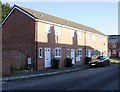
Modern houses on Phillip Street, Newport
These houses on the north side of the street contrast with much older, probably late Victorian, terraced housing on the other side of the street. http://www.geograph.org.uk/photo/1652519
Image: © Jaggery
Taken: 4 Jan 2010
0.06 miles