IMAGES TAKEN NEAR TO
Phillip Street, NEWPORT, NP19 0EE
Introduction
This page details the photographs taken nearby to Phillip Street, NP19 0EE by members of the Geograph project.
The Geograph project started in 2005 with the aim of publishing, organising and preserving representative images for every square kilometre of Great Britain, Ireland and the Isle of Man.

There are currently over 7.5m images from over14,400 individuals and you can help contribute to the project by visiting https://www.geograph.org.uk
Image Map
Images are licensed for reuse under creativecommons.org/licenses/by-sa/2.0
Notes
- Clicking on the map will re-center to the selected point.
- The higher the marker number, the further away the image location is from the centre of the postcode.
Image Listing (492 Images Found)
Images are licensed for reuse under creativecommons.org/licenses/by-sa/2.0
Image
Details
Distance
1
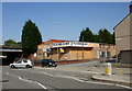
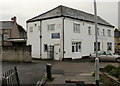
Floors-2-Go Wharf Road, Newport
Floors-2-Go got up and went. Their current premises http://www.geograph.org.uk/photo/3208939 are at the Maesglas Retail Park in the west of the city. This empty shop is on Wharf Road at the junction with Phillip Street.
Image: © Jaggery
Taken: 9 Aug 2009
0.01 miles
2
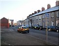
Phillip Street, Newport
Viewed from the corner of Wharf Road.
There is a contrast of housing on Phillip Street. On the right is terraced housing, probably late Victorian; on the left are modern houses http://www.geograph.org.uk/photo/1652531 , and beyond http://www.geograph.org.uk/photo/1652541 modern apartments.
Image: © Jaggery
Taken: 4 Jan 2010
0.01 miles
3
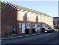
Modern houses on Phillip Street, Newport
These houses on the north side of the street contrast with much older, probably late Victorian, terraced housing on the other side of the street. http://www.geograph.org.uk/photo/1652519
Image: © Jaggery
Taken: 4 Jan 2010
0.01 miles
4
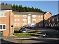
Apartments, Phillip Street, Newport
Modern apartment building on Phillip Street, adjacent to the Halstead Street junction.
Image: © Jaggery
Taken: 4 Jan 2010
0.01 miles
6
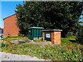
Jeffrey Street electricity substation, Newport
The green box on the corner of Jeffrey Street and Wharf Road is a Western Power Distribution electricity substation. Its identifier is JEFFREY ST. NEWPORT S/S No. 532488.
Image: © Jaggery
Taken: 21 Sep 2014
0.05 miles
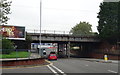
7
Broadband Has Evolved poster, Wharf Road, Newport
The Sky poster is on a Primesight hoarding on the side of the bridge
carrying the South Wales main railway line over Wharf Road.
Image: © Jaggery
Taken: 21 Sep 2014
0.05 miles
8
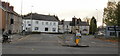
Wharf Road, Newport
Part of the B4237 from Chepstow Road to the George Street Bridge, Wharf Road is usually very busy. This untypically quiet scene was taken during a fleeting quiet interval on a Sunday afternoon.
Viewed from Chepstow Road.
Image: © Jaggery
Taken: 1 Nov 2009
0.05 miles
9
Crossroads Caring for Carers, Wharf Road, Newport
The Crossroads Carers share the building at 17-19 Wharf Road with Car Glass Ltd.
Newport Crossroads is an organisation that supports people who care for an elderly or disabled person at home, including children. It is an independent registered charity.
Image: © Jaggery
Taken: 12 Nov 2009
0.05 miles
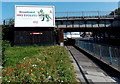
10
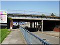
Railway bridge across Wharf Road,Newport
The bridge carries the Newport to London main line.
Image: © Jaggery
Taken: 9 Aug 2009
0.06 miles