IMAGES TAKEN NEAR TO
Feering Street, NEWPORT, NP19 0DU
Introduction
This page details the photographs taken nearby to Feering Street, NP19 0DU by members of the Geograph project.
The Geograph project started in 2005 with the aim of publishing, organising and preserving representative images for every square kilometre of Great Britain, Ireland and the Isle of Man.

There are currently over 7.5m images from over14,400 individuals and you can help contribute to the project by visiting https://www.geograph.org.uk
Image Map
Images are licensed for reuse under creativecommons.org/licenses/by-sa/2.0
Notes
- Clicking on the map will re-center to the selected point.
- The higher the marker number, the further away the image location is from the centre of the postcode.
Image Listing (291 Images Found)
Images are licensed for reuse under creativecommons.org/licenses/by-sa/2.0
Image
Details
Distance
1
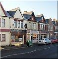
Beechwood Hire & Sales, Corporation Road, Newport
Located not in the Beechwood area, but at 264-272 Corporation Road.
Image: © Jaggery
Taken: 23 Sep 2009
0.04 miles
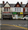
2
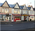
Madina Jewellers, Newport
Located at 254 Corporation Road, Madina Jewellers specialise in the sale and repair of 22 carat and 24 carat gold. Their neighbours are
256 Corporation Road - Print Source.
252 Corporation Road - Cityline Taxis.
Image: © Jaggery
Taken: 4 Jan 2010
0.04 miles
3
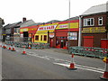
Food trio, Corporation Road
Located opposite Halstead Street are 3 eating places :
248 Corporation Road - King Balti restaurant and takeaway
246 Corporation Road - Doner King, kebabs, burgers, pizza, fried chicken.
244 Corporation Road - Shahnaz Balti - takeaway
Image: © Jaggery
Taken: 4 Jan 2010
0.04 miles
4
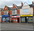
Super Sam Polish delicatessen and shop, Newport
Located on Corporation Road near the corner of Halstead Street, between a Lifestyle Express shop and City Properties.
Image: © Jaggery
Taken: 9 Jun 2012
0.04 miles
5

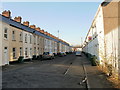
Severed end of Feering Street, Newport
Viewed from Kelvedon Street. Formerly vehicles could travel the whole length of Feering Street, http://www.geograph.org.uk/photo/1658697 but now access is permanently blocked by a bricked area containing trees, isolating the south-east fragment of Feering Street shown here. The blockage is temporarily reinforced by two containers, and the area is being used for the storage of barriers and coils of cable.
In the distance are the towers of George Street bridge. http://www.geograph.org.uk/photo/1658628
Image: © Jaggery
Taken: 4 Jan 2010
0.04 miles
6
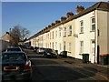
Feering Street, Newport
Looking towards Coverack Road.
A small section http://www.geograph.org.uk/photo/1658689 of Feering Street, at the southeast end, is separated from the main part seen here.
Image: © Jaggery
Taken: 4 Jan 2010
0.04 miles
7
Witham Street, Newport
Viewed from Kelvedon Street, looking towards Coverack Road.
The trees in the middle distance have been planted in a rectangular area which prevents the transit of traffic.
Image: © Jaggery
Taken: 4 Jan 2010
0.04 miles
8
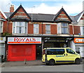
Royals takeaway, Corporation Road, Newport
Takeaway at 230 Corporation Road for fried chicken, spicy wings, burgers and kebabs.
Next door on the right is Adams Traditional Mens Barbers (no apostrophes in the name sign).
Image: © Jaggery
Taken: 9 Jun 2012
0.04 miles
9
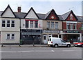
Spice Lounge and Shahnaz Balti, Newport
Located in Corporation Road opposite Halstead Street. Spice Lounge Indian
restaurant and takeaway is on the left. Shahnaz Balti takeaway is on the right.
Image: © Jaggery
Taken: 5 May 2014
0.07 miles
10
Vee's Island Twist, Newport
Vee's Island Twist is a Caribbean restaurant & takeaway at 246 Corporation Road.
Most of the text on the nameboard on the left is not in English (or Welsh).
Image: © Jaggery
Taken: 21 Feb 2020
0.07 miles