IMAGES TAKEN NEAR TO
Sunbeam Close, NEWPORT, NP19 0DF
Introduction
This page details the photographs taken nearby to Sunbeam Close, NP19 0DF by members of the Geograph project.
The Geograph project started in 2005 with the aim of publishing, organising and preserving representative images for every square kilometre of Great Britain, Ireland and the Isle of Man.

There are currently over 7.5m images from over14,400 individuals and you can help contribute to the project by visiting https://www.geograph.org.uk
Image Map
Images are licensed for reuse under creativecommons.org/licenses/by-sa/2.0
Notes
- Clicking on the map will re-center to the selected point.
- The higher the marker number, the further away the image location is from the centre of the postcode.
Image Listing (258 Images Found)
Images are licensed for reuse under creativecommons.org/licenses/by-sa/2.0
Image
Details
Distance
1
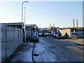
Kelvedon Street, Newport
Industrial and business properties at the far end of Kelvedon Street.
In the distance are the towers of George Street Bridge. http://www.geograph.org.uk/photo/1658628
Image: © Jaggery
Taken: 4 Jan 2010
0.03 miles
2
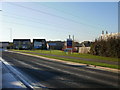
Great Western Wharf housing, Willenhall Street, Newport
Great Western Wharf is a housing development located on Willenhall Street, and extending to Argosy Way at the edge of the River Usk. Seen here is the northeastern edge, along Willenhall Street.
Image: © Jaggery
Taken: 4 Jan 2010
0.03 miles
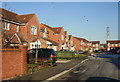
3
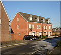
Sunbeam Close, Newport
Housing on the west side of Sunbeam Close, viewed from Argosy Way.
Image: © Jaggery
Taken: 4 Jan 2010
0.03 miles
4
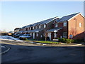
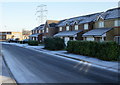
Frosty side of Sunbeam Close, Newport
The low elevation of the midwinter sun meant that this side of Sunbeam Close remained in shadow even at midday, and so hoar frost remained all day, after a dawn air temperature of minus 7 Celsius.
The other side of the close lived up to its name, and the houses were frost-free in sunshine. http://www.geograph.org.uk/photo/1658935
Image: © Jaggery
Taken: 4 Jan 2010
0.03 miles
5
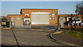
The Bridge training centre, Willenhall Street, Newport
Established in 1997, The Bridge is Newport City Council's training centre.
It is located on the corner of Willenhall Street and Lilleshall Street.
Image: © Jaggery
Taken: 4 Jan 2010
0.04 miles
6

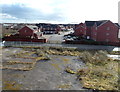
Severed end of Feering Street, Newport
Viewed from Kelvedon Street. Formerly vehicles could travel the whole length of Feering Street, http://www.geograph.org.uk/photo/1658697 but now access is permanently blocked by a bricked area containing trees, isolating the south-east fragment of Feering Street shown here. The blockage is temporarily reinforced by two containers, and the area is being used for the storage of barriers and coils of cable.
In the distance are the towers of George Street bridge. http://www.geograph.org.uk/photo/1658628
Image: © Jaggery
Taken: 4 Jan 2010
0.06 miles
7
Argosy Way houses viewed from George Street bridge, Newport
Viewed from the NE side of this http://www.geograph.org.uk/photo/1658628 bridge over the River Usk.
Image: © Jaggery
Taken: 14 Feb 2013
0.09 miles
8
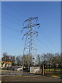
Pylon, Lilleshall Street, Newport
A pylon dominates the eastern edge of Newport City Council's The Bridge training centre. http://www.geograph.org.uk/photo/1658886
Image: © Jaggery
Taken: 4 Jan 2010
0.09 miles
9
Houses on Willenhall Street, Newport
Part of the Great Western Wharf housing development.
That's not a dusting of snow on surfaces, but hoar frost remaining in shaded areas after a dawn air temperature of minus 7 Celsius, and an air temperature about zero Celsius when the photo was taken.
Image: © Jaggery
Taken: 4 Jan 2010
0.09 miles
10
Excelsior Close, Newport
Houses on the west side of Excelsior Close, viewed from near the Argosy Way junction.
Image: © Jaggery
Taken: 4 Jan 2010
0.09 miles