IMAGES TAKEN NEAR TO
Abbot Close, NEWPORT, NP18 3TA
Introduction
This page details the photographs taken nearby to Abbot Close, NP18 3TA by members of the Geograph project.
The Geograph project started in 2005 with the aim of publishing, organising and preserving representative images for every square kilometre of Great Britain, Ireland and the Isle of Man.

There are currently over 7.5m images from over14,400 individuals and you can help contribute to the project by visiting https://www.geograph.org.uk
Image Map
Images are licensed for reuse under creativecommons.org/licenses/by-sa/2.0
Notes
- Clicking on the map will re-center to the selected point.
- The higher the marker number, the further away the image location is from the centre of the postcode.
Image Listing (98 Images Found)
Images are licensed for reuse under creativecommons.org/licenses/by-sa/2.0
Image
Details
Distance
1
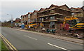
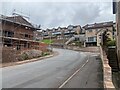
Lodge Road house construction site near Trinity View, Caerleon
Viewed on December 31st 2018. A March 2017 Google Street View
shows a fenced-off site being prepared for construction.
Image: © Jaggery
Taken: 31 Dec 2018
0.03 miles
2
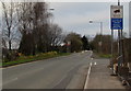
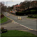
Unsuitable route for HGVs 100 yards ahead, Lodge Road, Caerleon
At the western end of Lodge Road, near the Trinity View junction.
100 yards ahead, Pillmawr Road towards the Malpas area of Newport
is unsuitable for heavy goods vehicles. The text is also in Welsh.
Image: © Jaggery
Taken: 31 Dec 2018
0.03 miles
3
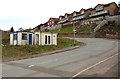
Sales office, Trinity View, Caerleon
Viewed on December 31st 2018. Houses are being built https://www.geograph.org.uk/photo/6015744 on Lodge Road behind the camera.
Image: © Jaggery
Taken: 31 Dec 2018
0.04 miles
4
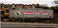
Mitsui O.S.K. Lines container, Lodge Road, Caerleon
In a building site near these https://www.geograph.org.uk/photo/6015744 houses being built in December 2018.
Image: © Jaggery
Taken: 31 Dec 2018
0.04 miles
5
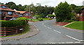
West along Lodge Road, Caerleon
Towards Pillmawr Road and the Malpas area of Newport. The Roman Reach junction is on the left.
A house construction site https://www.geograph.org.uk/photo/6015744 is on the right.
Image: © Jaggery
Taken: 31 Dec 2018
0.04 miles
7
Trinity Croft, Caerleon
Trinity Croft, from the junction with Pillmawr Road. Trinity Croft forms a loop around Hill Croft before rejoining Pillmawr Road. This is the view of the junction that is nearer to Caerleon.
Image: © Jaggery
Taken: 27 Aug 2009
0.05 miles
8
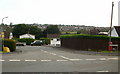
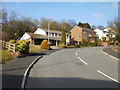
Roman Reach,Caerleon
Roman Reach from its eastern junction with Pillmawr Road. It forms a loop before rejoining Pillmawr Road. http://www.geograph.org.uk/photo/1461382 for a close up view of the yellow sign on the left
Image: © Jaggery
Taken: 27 Aug 2009
0.05 miles
9
No Cold Callers in Roman Reach
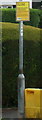
The sign at the eastern entrance http://www.geograph.org.uk/photo/1461373 to Roman Reach,Caerleon makes a change from the more usual ".... welcomes careful drivers". I stayed on the safe side of the sign, so cannot report what kind of warm reception awaited transgressors. No cauldrons of boiling oil were to be seen...
Image: © Jaggery
Taken: 27 Aug 2009
0.05 miles
10
Lower end of Trinity View, Caerleon
Houses on the west side of Trinity View, near the junction with Pillmawr Road.
Trinity View climbs steeply towards the edge of Lodge Hill (the natural feature, not the road).
Image: © Jaggery
Taken: 13 Mar 2010
0.05 miles