IMAGES TAKEN NEAR TO
Trinity View, NEWPORT, NP18 3SU
Introduction
This page details the photographs taken nearby to Trinity View, NP18 3SU by members of the Geograph project.
The Geograph project started in 2005 with the aim of publishing, organising and preserving representative images for every square kilometre of Great Britain, Ireland and the Isle of Man.

There are currently over 7.5m images from over14,400 individuals and you can help contribute to the project by visiting https://www.geograph.org.uk
Image Map
Images are licensed for reuse under creativecommons.org/licenses/by-sa/2.0
Notes
- Clicking on the map will re-center to the selected point.
- The higher the marker number, the further away the image location is from the centre of the postcode.
Image Listing (81 Images Found)
Images are licensed for reuse under creativecommons.org/licenses/by-sa/2.0
Image
Details
Distance
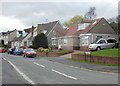
1
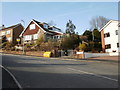
Trinity View houses adjacent to Trinity Lane, Caerleon
The steep climb from Pillmawr Road continues. These houses are on the east side of Trinity View, either side of Trinity Lane. http://www.geograph.org.uk/photo/1752286
Image: © Jaggery
Taken: 13 Mar 2010
0.01 miles
2
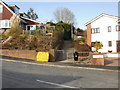
Trinity Lane, Caerleon
Trinity Lane heads away from Trinity View.
Image: © Jaggery
Taken: 13 Mar 2010
0.01 miles
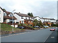
3
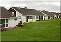
Oakfield, Caerleon
Bungalows on the south side of Oakfield, a cul-de-sac on the west side of Lodge Hill, opposite Anthony Drive.
Image: © Jaggery
Taken: 5 Apr 2010
0.05 miles
4
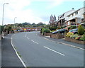
Caerleon : Trinity View climbs away from Trinity Lane
Trinity View continues its steep climb away from Pillmawr Road after a sharp bend opposite Trinity Lane. http://www.geograph.org.uk/photo/1752286
Image: © Jaggery
Taken: 16 Oct 2010
0.05 miles
5
Augustan Close, Caerleon
Augustan Close is one of several suburban roads on the west side of Lodge Hill.
Seen here are a few of the 22 houses in the close, built in the late 1960s.
Image: © Jaggery
Taken: 5 Apr 2010
0.07 miles
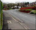
6
Caerleon : Trinity View begins its descent to Pillmawr Road
After a section of fairly level roadway http://www.geograph.org.uk/photo/2114209 in its central section, a gentle descent ahead towards Pillmawr Road will soon become much steeper. The houses are on the north side of the road.
Image: © Jaggery
Taken: 16 Oct 2010
0.07 miles
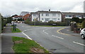
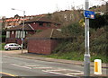
7
Trinity View, Caerleon
The southeast part of Trinity View viewed from near the corner of Lodge Road.
Image: © Jaggery
Taken: 31 Dec 2018
0.09 miles
8
Nearing the top of Lodge Hill, Caerleon
The suburban road Lodge Hill climbs straight ahead towards The Paddocks. The main road bends to the right, into Anthony Drive.
Image: © Jaggery
Taken: 5 Apr 2010
0.11 miles
9
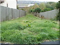
Grassy descent from Trinity View, Caerleon
Opposite a bend at the northernmost point of Trinity View, a grassy track descends steeply towards a small wooded area named Hill Croft. In the distance, at a much lower level, is the River Usk.
Image: © Jaggery
Taken: 16 Oct 2010
0.11 miles
10
Cycle route direction sign in Caerleon 3 miles from Newport city centre
The sign alongside Lodge Road points left towards Roman Reach. (88) on the sign indicates that the route leads to National Cycle Network Route 88 but is not part of it. National Cycle Network Route 88 is a proposed mainly coastal route from Newport to Margam Country Park via Cardiff and Bridgend. In 2018, the route is incomplete.
Image: © Jaggery
Taken: 31 Dec 2018
0.12 miles