IMAGES TAKEN NEAR TO
Forge Close, NEWPORT, NP18 3PU
Introduction
This page details the photographs taken nearby to Forge Close, NP18 3PU by members of the Geograph project.
The Geograph project started in 2005 with the aim of publishing, organising and preserving representative images for every square kilometre of Great Britain, Ireland and the Isle of Man.

There are currently over 7.5m images from over14,400 individuals and you can help contribute to the project by visiting https://www.geograph.org.uk
Image Map
Images are licensed for reuse under creativecommons.org/licenses/by-sa/2.0
Notes
- Clicking on the map will re-center to the selected point.
- The higher the marker number, the further away the image location is from the centre of the postcode.
Image Listing (61 Images Found)
Images are licensed for reuse under creativecommons.org/licenses/by-sa/2.0
Image
Details
Distance
1
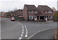
Corner of Forge Close and The Brades, Caerleon
Located on the east side of the B4236 Ponthir Road.
Image: © Jaggery
Taken: 8 Apr 2013
0.02 miles
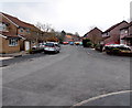
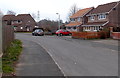
2
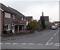
The Brades, Caerleon
The Brades is a residential cul-de-sac, viewed from the corner of Forge Close.
Image: © Jaggery
Taken: 8 Apr 2013
0.03 miles
3
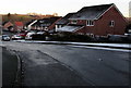
Frosty side of Forge Close, Caerleon
During a period of anticyclonic weather, patches of overnight hoar frost
remain on this north-facing part of Forge Close at 4pm on January 21st 2020.
Image: © Jaggery
Taken: 21 Jan 2020
0.04 miles
4
The Brades Storm sewage pumping station, Caerleon
This is one of two Welsh Water sewage pumping stations a few metres apart alongside this path. http://www.geograph.org.uk/photo/3404773
The other one is The Brades Foul sewage pumping station. http://www.geograph.org.uk/photo/3404790
Image: © Jaggery
Taken: 8 Apr 2013
0.04 miles
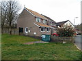
5
Forge Close, Caerleon
A view south from near the grassy area http://www.geograph.org.uk/photo/3404821 at the northern end of the close.
Image: © Jaggery
Taken: 8 Apr 2013
0.04 miles
6
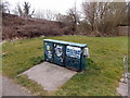
The Brades Foul sewage pumping station, Caerleon
This is one of two Welsh Water sewage pumping stations a few metres apart alongside this path. http://www.geograph.org.uk/photo/3404773
The other one is The Brades Storm sewage pumping station. http://www.geograph.org.uk/photo/3404784
Image: © Jaggery
Taken: 8 Apr 2013
0.05 miles
7
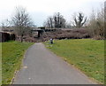
Path from Forge Close, Caerleon
The path east from Forge Close passes under this http://www.geograph.org.uk/photo/3404772 railway bridge 40 metres ahead.
Image: © Jaggery
Taken: 8 Apr 2013
0.06 miles
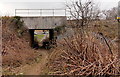
8
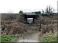
Railway bridge near Forge Close Caerleon
A path from Forge Close passes under the bridge carrying the Welsh Marches railway.
On the far side are riverside fields and a rugby pitch.
Image: © Jaggery
Taken: 8 Apr 2013
0.06 miles
9
A gap in the houses, Forge Close, Caerleon
A path http://www.geograph.org.uk/photo/3404773 between the houses leads to an underpass beneath a railway line.
Image: © Jaggery
Taken: 8 Apr 2013
0.06 miles
10
Railway bridge near Forge Close, Caerleon
Viewed from the field http://www.geograph.org.uk/photo/3404806 side of the bridge carrying the Welsh Marches railway.
Image: © Jaggery
Taken: 8 Apr 2013
0.06 miles