IMAGES TAKEN NEAR TO
College Road, NEWPORT, NP18 3NR
Introduction
This page details the photographs taken nearby to College Road, NP18 3NR by members of the Geograph project.
The Geograph project started in 2005 with the aim of publishing, organising and preserving representative images for every square kilometre of Great Britain, Ireland and the Isle of Man.

There are currently over 7.5m images from over14,400 individuals and you can help contribute to the project by visiting https://www.geograph.org.uk
Image Map
Images are licensed for reuse under creativecommons.org/licenses/by-sa/2.0
Notes
- Clicking on the map will re-center to the selected point.
- The higher the marker number, the further away the image location is from the centre of the postcode.
Image Listing (137 Images Found)
Images are licensed for reuse under creativecommons.org/licenses/by-sa/2.0
Image
Details
Distance
1
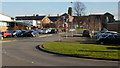
Caerleon campus, University of Wales, Newport
Viewed from the path along the northern perimeter of the campus.
Image: © Jaggery
Taken: 11 Feb 2010
0.04 miles
2
Forge Cottages, Caerleon
Located on Ponthir Road, between Brooklea http://www.geograph.org.uk/photo/3404864 and Forge Close.
Image: © Jaggery
Taken: 17 Oct 2010
0.10 miles
3
Ponthir Road approaches Caerleon boundary sign
The view south along Ponthir Road, from the corner of Forge Close. http://www.geograph.org.uk/photo/2124722
I doubt the accuracy of the placement of the sign, since Forge Close, and various business premises behind the camera, are all shown in reference works as being in Caerleon, not Ponthir.
Image: © Jaggery
Taken: 17 Oct 2010
0.10 miles
4
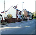
University buildings, Caerleon
The SW edge of Caerleon Campus of the University of Wales, Newport, viewed from Lodge Road near the corner of St Cadoc's Close.
Image: © Jaggery
Taken: 22 Mar 2012
0.10 miles
5
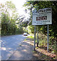
Northern boundary of Caerleon
Alongside the B4236 Ponthir Road. Caerleon was the ancient Roman fortress town of Isca Silurum (or Isca Augusta). The text is also in Welsh. There is no boundary sign on the back of this one, only a Your Speed indicator. https://www.geograph.org.uk/photo/5918551
Image: © Jaggery
Taken: 25 Sep 2018
0.11 miles
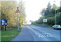
6
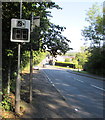
Your Speed indicator at the northern end of Caerleon
Alongside the B4236 Ponthir Road. Currently off, the display turns on to show the speed in green if an approaching vehicle is within the speed limit, or red if over the speed limit. Behind the Your Speed indicator is the grey back of the Caerleon boundary sign. https://www.geograph.org.uk/photo/5918546
Image: © Jaggery
Taken: 25 Sep 2018
0.11 miles
7
Entrance to University of South Wales, Caerleon campus
Image: © John Lord
Taken: 9 Feb 2015
0.11 miles
8

Entrance road to the former Caerleon Campus
From the northeast side of Lodge Road viewed in December 2018.
The Caerleon Campus of the University of Wales, Newport closed in 2016.
The name signs seen here https://www.geograph.org.uk/photo/1713206 in 2009 have gone.
Image: © Jaggery
Taken: 31 Dec 2018
0.11 miles
9
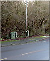
Dark green cabinets alongside Ponthir Road, Caerleon
Telecoms cabinets on the west side of the B4236 Ponthir Road.
Image: © Jaggery
Taken: 21 Jan 2020
0.11 miles
10
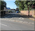
No Entry signs, College Crescent, Caerleon
One-way road viewed across the B4236.
Image: © Jaggery
Taken: 25 Sep 2018
0.12 miles