IMAGES TAKEN NEAR TO
Great Field Close, NP18 2DJ
Introduction
This page details the photographs taken nearby to Great Field Close, NP18 2DJ by members of the Geograph project.
The Geograph project started in 2005 with the aim of publishing, organising and preserving representative images for every square kilometre of Great Britain, Ireland and the Isle of Man.

There are currently over 7.5m images from over14,400 individuals and you can help contribute to the project by visiting https://www.geograph.org.uk
Image Map
Images are licensed for reuse under creativecommons.org/licenses/by-sa/2.0
Notes
- Clicking on the map will re-center to the selected point.
- The higher the marker number, the further away the image location is from the centre of the postcode.
Image Listing (18 Images Found)
Images are licensed for reuse under creativecommons.org/licenses/by-sa/2.0
Image
Details
Distance

2
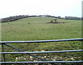
Small hill viewed from Cot Hill, Llanwern
The view SSW from a field gate on Cot Hill.
Image: © Jaggery
Taken: 26 Nov 2010
0.11 miles
3
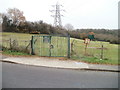
Padlocked gates to abandoned Ringland Allotments, Newport
Viewed across Cot Hill, near its junction with Ringland Way. The sign shows Ringland Allotments, but the former allotment plots are now covered by grass.
Image: © Jaggery
Taken: 26 Nov 2010
0.18 miles
4
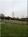
Pylon at southern edge of former Ringland Allotments, Newport
Viewed across Cot Hill near its junction with Ringland Way. Near the left edge of the view are padlocked gates http://www.geograph.org.uk/photo/2342032 at the entrance to the former Ringland Allotments.
Image: © Jaggery
Taken: 26 Nov 2010
0.18 miles
5
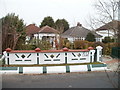
Distinctive perimeter wall, Cot Hill, Llanwern
An eye-catching wall at the front of a Cot Hill house.
Image: © Jaggery
Taken: 26 Nov 2010
0.18 miles
6

Cae Twmpin Road houses, Llanwern
Viewed from the corner of Hen Chwarel Drive in February 2023.
The name sign shows CAE TWMPIN ROAD and the Welsh HEOL CAE TWMPIN
Image: © Jaggery
Taken: 26 Feb 2023
0.18 miles
7
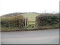
Stile to a footpath, Cot Hill, Llanwern
Opposite Little Milton Farm, a stile on the SW side of Cot Hill leads to a public footpath across a field.
Image: © Jaggery
Taken: 26 Nov 2010
0.20 miles

9
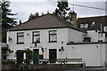
The Milton Hotel
Village of Milton near Newport
Image: © Adrian and Janet Quantock
Taken: 7 Apr 2006
0.22 miles
10

Pylons and gate to Ringland allotments
From Cot Hill, the allotment site looks unused.
Image: © Steve Fareham
Taken: 15 Feb 2011
0.22 miles