IMAGES TAKEN NEAR TO
Magor Road, NEWPORT, NP18 2BP
Introduction
This page details the photographs taken nearby to Magor Road, NP18 2BP by members of the Geograph project.
The Geograph project started in 2005 with the aim of publishing, organising and preserving representative images for every square kilometre of Great Britain, Ireland and the Isle of Man.

There are currently over 7.5m images from over14,400 individuals and you can help contribute to the project by visiting https://www.geograph.org.uk
Image Map
Images are licensed for reuse under creativecommons.org/licenses/by-sa/2.0
Notes
- Clicking on the map will re-center to the selected point.
- The higher the marker number, the further away the image location is from the centre of the postcode.
Image Listing (11 Images Found)
Images are licensed for reuse under creativecommons.org/licenses/by-sa/2.0
Image
Details
Distance
1
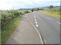
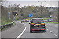
Lay-by, Magor Road
The lay-by is about half-way between Llanmartin and Langstone.
Image: © Jaggery
Taken: 14 Aug 2010
0.02 miles
2
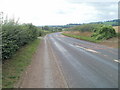
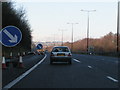
Magor Road west of Llanmartin
Ahead, the speed limit increases to 50mph along this section of Magor Road (B4245), just west of Llanmartin.
Image: © Jaggery
Taken: 14 Aug 2010
0.14 miles
3
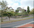
Houses on the eastern edge of Langstone
Houses on the north side of Magor Road, near the eastern approach to Langstone.
Image: © Jaggery
Taken: 14 Aug 2010
0.16 miles
4
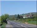
Houses on the road to Langstone
Attractive isolated group of houses on the B4245 just outside Langstone.
Image: © Ruth Sharville
Taken: 19 Apr 2007
0.19 miles
5
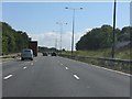
M4 Motorway approaching Underwood
The carriageways are separated both horizontally and vertically for about a mile between Langstone and Underwood.
Image: © J Whatley
Taken: 31 Aug 2010
0.19 miles
6
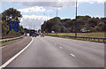
Newport : The M4 Motorway
The M4 Motorway heading through the Newport area of Wales.
Image: © Lewis Clarke
Taken: 10 Apr 2014
0.19 miles
7
M4 heading south east
Heading towards junction 23a
Image: © Julian P Guffogg
Taken: 9 Aug 2013
0.20 miles
8

Field entrance, Court Farm
The entrance is from Magor Road (B4245). The pinkish-red road markings are intended to alert motorists to a bend in the road, and an imminent reduction in the speed limit from 50mph to 30mph at the western edge of Llanmartin.
Image: © Jaggery
Taken: 14 Aug 2010
0.20 miles
10
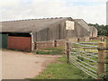
Court Farm Stables, Llanmartin
Horse training premises, adjacent to Magor Road (B4245).
Image: © Jaggery
Taken: 14 Aug 2010
0.22 miles