IMAGES TAKEN NEAR TO
Usk Road, NEWPORT, NP18 1LP
Introduction
This page details the photographs taken nearby to Usk Road, NP18 1LP by members of the Geograph project.
The Geograph project started in 2005 with the aim of publishing, organising and preserving representative images for every square kilometre of Great Britain, Ireland and the Isle of Man.

There are currently over 7.5m images from over14,400 individuals and you can help contribute to the project by visiting https://www.geograph.org.uk
Image Map
Images are licensed for reuse under creativecommons.org/licenses/by-sa/2.0
Notes
- Clicking on the map will re-center to the selected point.
- The higher the marker number, the further away the image location is from the centre of the postcode.
Image Listing (10 Images Found)
Images are licensed for reuse under creativecommons.org/licenses/by-sa/2.0
Image
Details
Distance
1
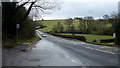
Kemys View, Usk Road
This part of Usk Road is often considered part of Caerleon, though it is about a kilometre northeast of the built-up area of Caerleon.
Image: © Jaggery
Taken: 29 Oct 2009
0.06 miles
2
Caerllion and Usk Valley, Monmouthshire
View from the Marches Way at Caerllion looking east over the Usk Valley to Kemays Ridge, the highest point of which is Caer Licyn 792ft asl.
Image: © Ralph Rawlinson
Taken: 17 Dec 2005
0.12 miles
3
Oak tree in a field adjacent to Kemys View
An oak sits in the centre of a field on the west side of Usk Road, between Kemys View http://www.geograph.org.uk/photo/1864427 and Sor Brook.
Image: © Jaggery
Taken: 30 Aug 2010
0.12 miles
4
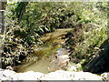
Sor Brook, Usk Road
Viewed from Sor Brook Bridge, Sor Brook flows away from Usk Road on a meandering course towards the River Usk.
Image: © Jaggery
Taken: 30 Aug 2010
0.18 miles
5
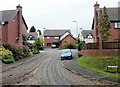
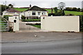
Twyn Oaks, Caerleon
Modern housing on the north side of Usk Road, about 500 metres east of the built-up area of Caerleon.
Image: © Jaggery
Taken: 29 Oct 2009
0.20 miles
6
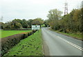
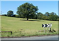
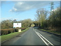
Usk road from Caerleon approaches Monmouthshire
The road heading north from Caerleon to Usk approaches the north limits of the City of Newport and the start of Monmouthshire. In the distance, on the right, is the turning for Llanhennock.http://www.geograph.org.uk/photo/1862490
Image: © Jaggery
Taken: 29 Oct 2009
0.20 miles
7
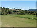
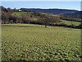
Farmland adjacent to Usk Road, Caerleon
The view from Usk Road across farmland towards a pylon on a wooded hillside.
Image: © Jaggery
Taken: 30 Aug 2010
0.20 miles
8
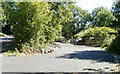
No access ahead from Usk Road, Caerleon
Locked gates block access to this side road from Usk Road (on the left edge of the photo). A sign states that ahead is a construction site for the 2010 Ryder Cup. Would-be intruders are warned of patrol dogs on the site.
Image: © Jaggery
Taken: 30 Aug 2010
0.22 miles
9
Usk Road at Pont Sor
This was the old A449 trunk road before the dual carriageway was built on the other side of the Usk.
Image: © Jonathan Billinger
Taken: 19 Feb 2016
0.23 miles
10
Usk Road at Monmouthshire county boundary
Image: © Colin Pyle
Taken: 2 Jan 2015
0.24 miles