IMAGES TAKEN NEAR TO
Old Hill Crescent, NEWPORT, NP18 1JN
Introduction
This page details the photographs taken nearby to Old Hill Crescent, NP18 1JN by members of the Geograph project.
The Geograph project started in 2005 with the aim of publishing, organising and preserving representative images for every square kilometre of Great Britain, Ireland and the Isle of Man.

There are currently over 7.5m images from over14,400 individuals and you can help contribute to the project by visiting https://www.geograph.org.uk
Image Map
Images are licensed for reuse under creativecommons.org/licenses/by-sa/2.0
Notes
- Clicking on the map will re-center to the selected point.
- The higher the marker number, the further away the image location is from the centre of the postcode.
Image Listing (61 Images Found)
Images are licensed for reuse under creativecommons.org/licenses/by-sa/2.0
Image
Details
Distance
1
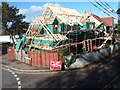
House construction, Christchurch, Newport
A mid October 2012 view of the corner of Old Hill and Old Hill Crescent, Christchurch.
Image: © Jaggery
Taken: 16 Oct 2012
0.04 miles
2
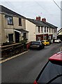
Old Hill houses, Christchurch, Newport
Alongside the descent towards Caerleon from the centre of Christchurch.
Image: © Jaggery
Taken: 22 Jan 2023
0.05 miles
3
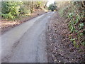
Steepest section of Old Hill, Christchurch
Just when the walker's weary legs have almost reached the limit of their endurance, Old Hill's gradient steepens yet again as it approaches the summit of Christchurch.
Image: © Jaggery
Taken: 21 Feb 2010
0.06 miles
4
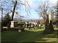
Churchyard, and view, Christchurch, Newport
Image: © Ruth Sharville
Taken: 26 Feb 2010
0.06 miles
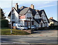
5
East side of the Greyhound Inn, Christchurch, Newport
In the centre of Christchurch, on the ridge on the south side of the Usk valley.
Image: © Jaggery
Taken: 22 Jan 2023
0.07 miles
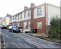
6
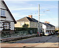
Old Hill houses, Christchurch
Houses at the top end of Old Hill, adjacent to the Greyhound Inn. http://www.geograph.org.uk/photo/1772735
Image: © Jaggery
Taken: 21 Feb 2010
0.07 miles
7
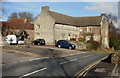
Church House and The Friars, Christchurch
Grade II listed building of rubble stone in the centre of Christchurch, located next to the church. http://www.geograph.org.uk/photo/1726658
The original building probably appeared in the late medieval period. It was considerably enlarged in the 16th century. The external appearance of the building is much as it would have looked in 1600. The datable features are of that period, or reproductions of that period.
It was one house in 1980 but is now two private dwellings, 1 and 2 Cats Ash Road. The black car is parked in front of Church House ; The Friars is at right angles to Church House.
Image: © Jaggery
Taken: 21 Feb 2010
0.07 miles
8
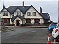
Greyhound Inn, Christchurch, Newport
Located at the top of Christchurch hill, opposite the church.http://www.geograph.org.uk/photo/1726658
Weekend attractions include live entertainment most Fridays and Saturdays, and a quiz on Sundays.
http://www.geograph.org.uk/photo/3181514 to a front view.
Image: © Jaggery
Taken: 21 Feb 2010
0.07 miles
9
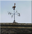
Weather vane, Christchurch
The weather vane at the top of the tower of Holy Trinity Church,http://www.geograph.org.uk/photo/1726658 Christchurch.
Image: © Jaggery
Taken: 26 Mar 2010
0.07 miles
10
Houses at the top end of Old Hill, Christchurch
The steep (at times very steep) climb from the corner of Bulmore Road and the foot of Belmont Hill nears its end as the gradient becomes gentler.
Image: © Jaggery
Taken: 21 Feb 2010
0.07 miles