IMAGES TAKEN NEAR TO
Candwr Road, NEWPORT, NP18 1HU
Introduction
This page details the photographs taken nearby to Candwr Road, NP18 1HU by members of the Geograph project.
The Geograph project started in 2005 with the aim of publishing, organising and preserving representative images for every square kilometre of Great Britain, Ireland and the Isle of Man.

There are currently over 7.5m images from over14,400 individuals and you can help contribute to the project by visiting https://www.geograph.org.uk
Image Map
Images are licensed for reuse under creativecommons.org/licenses/by-sa/2.0
Notes
- Clicking on the map will re-center to the selected point.
- The higher the marker number, the further away the image location is from the centre of the postcode.
Image Listing (4 Images Found)
Images are licensed for reuse under creativecommons.org/licenses/by-sa/2.0
Image
Details
Distance
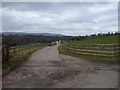
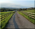
1
Road to Ponthir
A view to the south of the hamlet of Common Cefn-Ilwyn.
Image: © Jaggery
Taken: 27 Sep 2011
0.08 miles
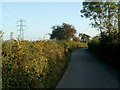
2
Access lane to Candwr Farm north of Ponthir
The farm buildings are about 200 metres away.
Image: © Jaggery
Taken: 27 Sep 2011
0.22 miles
3
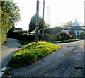
A grass triangle at a road junction, Common Cefn-Ilwyn
There is a yellow sign on the post giving the location of a hydrant (which is hidden
behind the mound of the triangle). The road on the left heads south towards Ponthir.
Image: © Jaggery
Taken: 27 Sep 2011
0.24 miles