IMAGES TAKEN NEAR TO
Hitchen Hollow, CHEPSTOW, NP16 7RH
Introduction
This page details the photographs taken nearby to Hitchen Hollow, NP16 7RH by members of the Geograph project.
The Geograph project started in 2005 with the aim of publishing, organising and preserving representative images for every square kilometre of Great Britain, Ireland and the Isle of Man.

There are currently over 7.5m images from over14,400 individuals and you can help contribute to the project by visiting https://www.geograph.org.uk
Image Map
Images are licensed for reuse under creativecommons.org/licenses/by-sa/2.0
Notes
- Clicking on the map will re-center to the selected point.
- The higher the marker number, the further away the image location is from the centre of the postcode.
Image Listing (15 Images Found)
Images are licensed for reuse under creativecommons.org/licenses/by-sa/2.0
Image
Details
Distance
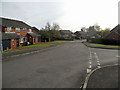
2
Beachley Road, Beachley
The view north along Beachley Road, to the south of Beachley Barracks (where no photography is allowed).
Image: © Jaggery
Taken: 17 Sep 2010
0.05 miles
3
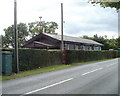
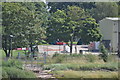
The Bungalow, Beachley
The Bungalow is a 20 metre long, single storey wooden building on the east side of Beachley Road, adjacent to the west bank of the River Severn.
The instrument at the top of a pole on the left is an anemometer, for measuring wind speed.
Image: © Jaggery
Taken: 17 Sep 2010
0.10 miles
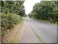
4
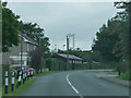
Beachley Road
Heading for Sedbury and Chepstow. This used to be the B4228, but it appears to have been downgraded.
Image: © David Purchase
Taken: 9 Oct 2016
0.11 miles
5
Beachley Army Apprentices College
Image: © Nick Mutton 01329 000000
Taken: 23 Jul 2010
0.16 miles
6
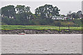
Forest of Dean : River Severn Riverbank
Looking towards the banks of the River Severn Estuary.
Image: © Lewis Clarke
Taken: 24 Jul 2015
0.17 miles
7
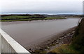
From England to Wales across the Wye from the M48 west of Beachley
Viewed from Wye Bridge. The Wye is near its mouth at the confluence with the River Severn.
The river is about 270 metres wide under the bridge. The width of water varies with the tide.
The midpoint on the river here marks the border between England (on this side) and Wales.
Image: © Jaggery
Taken: 15 Dec 2013
0.18 miles
9
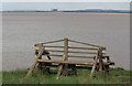
Driftwood Bench
Severn foreshore, Beachley.
Image: © ben hollier
Taken: 22 May 2013
0.21 miles
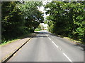
10

The River Severn at Beachley
Looking upstream.
Image: © David Purchase
Taken: 9 Oct 2016
0.22 miles