IMAGES TAKEN NEAR TO
Woodcroft, CHEPSTOW, NP16 7PX
Introduction
This page details the photographs taken nearby to NP16 7PX by members of the Geograph project.
The Geograph project started in 2005 with the aim of publishing, organising and preserving representative images for every square kilometre of Great Britain, Ireland and the Isle of Man.

There are currently over 7.5m images from over14,400 individuals and you can help contribute to the project by visiting https://www.geograph.org.uk
Image Map
Images are licensed for reuse under creativecommons.org/licenses/by-sa/2.0
Notes
- Clicking on the map will re-center to the selected point.
- The higher the marker number, the further away the image location is from the centre of the postcode.
Image Listing (92 Images Found)
Images are licensed for reuse under creativecommons.org/licenses/by-sa/2.0
Image
Details
Distance
1
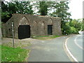
Coleford Road - interesting building
I have made substantial enquiries but no-one seems to know what this building ever was. Today it is a garage.
Image: © Nick Mutton 01329 000000
Taken: 14 Sep 2007
0.03 miles
2
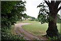
Recreation field in Tutshill
This open field seems to have been turned in to some kind of school running field.
Image: © Nick Mutton 01329 000000
Taken: 6 Jul 2010
0.03 miles
3
![A walk around the east bank of the River Wye [44]](https://s2.geograph.org.uk/geophotos/07/36/30/7363042_85e1ef10_120x120.jpg)
A walk around the east bank of the River Wye [44]
The path continues south through a small area of woodland.
The walk leaves Chepstow, crosses the River Wye, and ascends through Tutshill, following the long distance Offa’s Dyke Path. A diversion down the Lancaut Walk is taken before returning to rejoin Offa’s Dyke Path to Wintour’s Leap. After crossing Coleford Road, B4228, footpaths and roads are taken through Woodcroft and Tutshill to recross the river and return to the starting point. About 5 miles.
Image: © Michael Dibb
Taken: 3 Sep 2022
0.04 miles
4
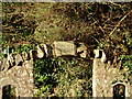
Woodcroft - Moyle Old School Lane sign
This sign is above an archway with an iron, green-painted, gate on the Offa's Dyke Path at Woodcroft, where the path leaves the B4228 to follow a more interesting route behind the houses. How many walkers notice this stone?
Image: © Roy Parkhouse
Taken: 16 Dec 2006
0.05 miles
5
Moyle Old School Lane
Llwybr Clawdd Offa yn gadael yr B4228 i ddilyn ffordd o'r enw Moyle Old School Lane.
Offa's Dyke path leaving the B4228 to follow a way called Moyle Old School Lane
Image: © Alan Richards
Taken: 20 Aug 1997
0.05 miles
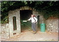
6
![A walk around the east bank of the River Wye [43]](https://s3.geograph.org.uk/geophotos/07/36/30/7363039_dc58d97e_120x120.jpg)
A walk around the east bank of the River Wye [43]
The old railway signals are in the garden of a house in Woodcroft. Seen from the B4228 road.
The walk leaves Chepstow, crosses the River Wye, and ascends through Tutshill, following the long distance Offa’s Dyke Path. A diversion down the Lancaut Walk is taken before returning to rejoin Offa’s Dyke Path to Wintour’s Leap. After crossing Coleford Road, B4228, footpaths and roads are taken through Woodcroft and Tutshill to recross the river and return to the starting point. About 5 miles.
Image: © Michael Dibb
Taken: 3 Sep 2022
0.06 miles
7
![A walk around the east bank of the River Wye [27]](https://s1.geograph.org.uk/geophotos/07/36/25/7362553_d9729fdb_120x120.jpg)
A walk around the east bank of the River Wye [27]
After following the B4228 for a short distance, the path leaves the road through this archway into Old School Lane. Probably erected in the mid 19th century, there is a rough segmental arch with an inscribed key stone. There is a small iron single gate with spiked rods. Listed, grade II, with details at: https://historicengland.org.uk/listing/the-list/list-entry/1299095
The walk leaves Chepstow, crosses the River Wye, and ascends through Tutshill, following the long distance Offa’s Dyke Path. A diversion down the Lancaut Walk is taken before returning to rejoin Offa’s Dyke Path to Wintour’s Leap. After crossing Coleford Road, B4228, footpaths and roads are taken through Woodcroft and Tutshill to recross the river and return to the starting point. About 5 miles.
Image: © Michael Dibb
Taken: 3 Sep 2022
0.06 miles

9
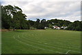
Recreation field in Tutshill
The recreation field seems to be being used by a school for running
Image: © Nick Mutton 01329 000000
Taken: 6 Jul 2010
0.07 miles
10
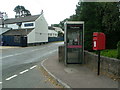
Woodcroft phone box & Rising Sun pub
Image: © Nick Mutton 01329 000000
Taken: 14 Sep 2007
0.07 miles