IMAGES TAKEN NEAR TO
Brockweir, CHEPSTOW, NP16 7NG
Introduction
This page details the photographs taken nearby to NP16 7NG by members of the Geograph project.
The Geograph project started in 2005 with the aim of publishing, organising and preserving representative images for every square kilometre of Great Britain, Ireland and the Isle of Man.

There are currently over 7.5m images from over14,400 individuals and you can help contribute to the project by visiting https://www.geograph.org.uk
Image Map
Images are licensed for reuse under creativecommons.org/licenses/by-sa/2.0
Notes
- Clicking on the map will re-center to the selected point.
- The higher the marker number, the further away the image location is from the centre of the postcode.
Image Listing (154 Images Found)
Images are licensed for reuse under creativecommons.org/licenses/by-sa/2.0
Image
Details
Distance
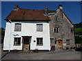
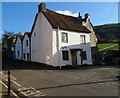
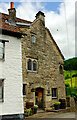
1

Old Malt House, Brockweir
A very odd looking building in Brockweir which apparently dates back at least as far as the 17th century, and with parts that may be medieval. A real mixture of styles, materials and dates.
Image: © Gordon Hatton
Taken: 17 Oct 2011
0.00 miles
2
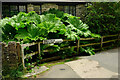
Gunnera, Brockweir
On the left of the camera in Image The Moravian church, reached by footpath FHE48 part 3, is shown in the images at https://www.geograph.org.uk/search.php?i=161618537 .
Image: © Derek Harper
Taken: 25 Jun 2021
0.01 miles
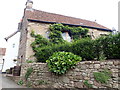
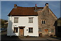
3
Old buildings in Brockweir village
The building on the right claims a medieval date, in the 14th century and is called the monk's house.
Image: © Jeremy Bolwell
Taken: 22 Jul 2012
0.01 miles
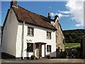
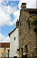
4
Monks Hall, Brockweir
14th Century Monks Hall, now used as holiday accommodation
Image: © Eirian Evans
Taken: 30 Aug 2019
0.01 miles
6
Malthouse, Brockweir
Viewed across Mill Hill. The corner house, Malthouse, is a few metres from The Brockweir Inn. http://www.geograph.org.uk/photo/3577306
Image: © Jaggery
Taken: 27 Nov 2011
0.01 miles
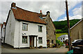
8
Malt House, Brockweir
The grade II* listed building is described as "dwelling and workshop or store, sometime malt house, now dwelling and pottery" at https://historicengland.org.uk/listing/the-list/list-entry/1186590?section=official-list-entry but, having been holiday accommodation, it now seems to be a five-bedroomed home. The building has distinctly different exteriors, with "original block in sandstone rubble with some carving on the principal south front, remainder painted rubble ... a two-storey original C15 or C16 block with gable to road, with later 2½ storey building forming an L, and C19 infill ... a complex historical growth ..." See other images at https://www.geograph.org.uk/search.php?i=161618229 .
The Offa's Dyke Path runs past, turning left at the junction with Mill Hill. Ahead is the listed former Post Office; see Image
Image: © Derek Harper
Taken: 25 Jun 2021
0.01 miles
9
Malt House, Brockweir
The grade II* listed building https://historicengland.org.uk/listing/the-list/list-entry/1186590?section=official-list-entry is also seen in https://www.geograph.org.uk/search.php?i=161618229 . The photos and description at https://historicengland.org.uk/listing/the-list/list-entry/1186590?section=comments-and-photos may help to disentangle the complex history of the building.
The Offa's Dyke Path turns right here beside the building.
Image: © Derek Harper
Taken: 25 Jun 2021
0.01 miles
10
Malt House, Brockweir
See also https://www.geograph.org.uk/search.php?i=161618229 and https://historicengland.org.uk/listing/the-list/list-entry/1186590?section=official-list-entry for the description of this grade II* listed building.
Image: © Derek Harper
Taken: 25 Jun 2021
0.01 miles