IMAGES TAKEN NEAR TO
Kellys Lane, CHEPSTOW, NP16 7LY
Introduction
This page details the photographs taken nearby to Kellys Lane, NP16 7LY by members of the Geograph project.
The Geograph project started in 2005 with the aim of publishing, organising and preserving representative images for every square kilometre of Great Britain, Ireland and the Isle of Man.

There are currently over 7.5m images from over14,400 individuals and you can help contribute to the project by visiting https://www.geograph.org.uk
Image Map
Images are licensed for reuse under creativecommons.org/licenses/by-sa/2.0
Notes
- Clicking on the map will re-center to the selected point.
- The higher the marker number, the further away the image location is from the centre of the postcode.
Image Listing (11 Images Found)
Images are licensed for reuse under creativecommons.org/licenses/by-sa/2.0
Image
Details
Distance
1
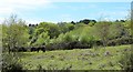
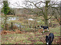
Ponies in Poor's Allotment
Wild ponies are now permitted to graze in this area of mixed woodland and grassland.
Image: © Colin Bews
Taken: 11 May 2015
0.18 miles
3
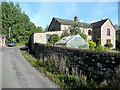
House on Rosemary Lane
A substantial red sandstone house with fine views eastwards over the Severn estuary.
Image: © Jonathan Billinger
Taken: 27 Aug 2010
0.21 miles
4
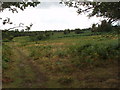
Poor's Allotment, Tidenham
The original purpose of the land was to be used as allotments, so the poor could graze their livestock and grow their crops, the charity was set up under an inclosure award dated 21st July 1815.
It covers 108 acres and is now managed by English Nature as an SSSI, see ST5598 for view to the East.
Grants of money are now given for the benefit of the poor, and managed by trustees.
Image: © Christopher Clift
Taken: 19 Aug 2006
0.21 miles
5
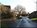
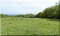
Rosemary Lane junction with Kelly's Lane
The picture is of Rosemary lane, where it is crossed by "The Gloucestershire Way" a long distance walk, Rosemary Lane joins the B4228 and A48.
In the far distance can be seen the River Severn.
Image: © Christopher Clift
Taken: 21 Nov 2006
0.22 miles
6

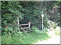
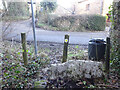
Stone Stile, Tidenham Chase
Off Rosemary Lane, opposite Kellys Lane on Gloucestershire footpaths FTM24 & FTM25 looking SW from the road. The view looking to Kellys Lane is Image
Image: © Mr Red
Taken: 17 Jan 2022
0.22 miles
7
Stone Stile, Tidenham Chase
Off Rosemary Lane, opposite Kellys Lane on Gloucestershire footpaths FTM24 & FTM25 looking NW to the road. The view looking into the footpaths is Image
Image: © Mr Red
Taken: 17 Jan 2022
0.22 miles
8
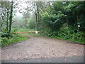
Track into woodland off Rosemary Lane
A barrier prevents unwelcome vehicular access.
Image: © Jeremy Bolwell
Taken: 12 Aug 2012
0.22 miles
9
Spring and pond on Poor's Allotment
The spring and pond on Poor's Allotment, a site of Special Scientific interest, section 28 of the Country side act 1981.
Image: © Christopher Clift
Taken: 1 Dec 2009
0.23 miles
10
Poor's Allotment in Spring
Looking towards the Severn Estuary. Note the bluebells in the foreground.
Image: © Colin Bews
Taken: 11 May 2015
0.24 miles