IMAGES TAKEN NEAR TO
Stroat, CHEPSTOW, NP16 7LR
Introduction
This page details the photographs taken nearby to NP16 7LR by members of the Geograph project.
The Geograph project started in 2005 with the aim of publishing, organising and preserving representative images for every square kilometre of Great Britain, Ireland and the Isle of Man.

There are currently over 7.5m images from over14,400 individuals and you can help contribute to the project by visiting https://www.geograph.org.uk
Image Map
Images are licensed for reuse under creativecommons.org/licenses/by-sa/2.0
Notes
- Clicking on the map will re-center to the selected point.
- The higher the marker number, the further away the image location is from the centre of the postcode.
Image Listing (17 Images Found)
Images are licensed for reuse under creativecommons.org/licenses/by-sa/2.0
Image
Details
Distance
4
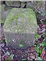
Old Milestone by the A48, near Stroat House, Woolaston Parish
Metal plate attached to stone post by the A48, in parish of WOOLASTON (FOREST OF DEAN District), opposite Stroat Farm, on grass verge adjacent to old roadside wall, on South side of road. NC erected by the Chepstow District turnpike trust in the 19th century.
Inscription reads:-
TO
CHEPSTOW
4
MILES
Cut bench mark and rivet on top.
Milestone Society National ID: GL_GLCW24.
Image: © K Walker & R Harvey
Taken: 17 Feb 2001
0.04 miles
5
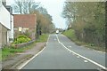
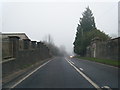
Tidenham : Stroat - A48
The A48 heading through Stroat.
Image: © Lewis Clarke
Taken: 22 Mar 2023
0.06 miles
6
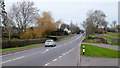
A48 at Stroat
Looking north-east towards Lydney and Gloucester.
Image: © Jonathan Billinger
Taken: 8 Feb 2012
0.13 miles
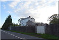
7
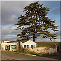
North side of Stroat Evangelical Church dwarfed by a tree
The location is alongside the A48 Gloucester Road between Chepstow and Lydney.
Image: © Jaggery
Taken: 1 Jan 2013
0.16 miles
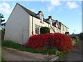
8
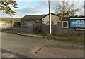
Stroat Evangelical Church
Located on the east side of the A48 Gloucester Road between Chepstow and Lydney.
The church traces its origins back to the 1880s. In 1889 Squire Morgan, a member of an evangelical Anglican family, bought a plot of ground at Stroat on which was erected a corrugated iron building, known as the Iron Room.
Image: © Jaggery
Taken: 1 Jan 2013
0.17 miles
9
Stroat Evangelical Church
Churches and chapels (no. 4). The mission church has been serving the community for over 130 years. http://www.stroatchurch.org.uk/index.php/about-us/history/120-years-anniversary
Image: © Andy Stott
Taken: 8 Jan 2012
0.18 miles
10
A remnant of the old Gloucester Road, near Stroat Evangelical church
Image: © Ruth Sharville
Taken: 18 Nov 2022
0.18 miles