IMAGES TAKEN NEAR TO
Tidenham, CHEPSTOW, NP16 7LJ
Introduction
This page details the photographs taken nearby to NP16 7LJ by members of the Geograph project.
The Geograph project started in 2005 with the aim of publishing, organising and preserving representative images for every square kilometre of Great Britain, Ireland and the Isle of Man.

There are currently over 7.5m images from over14,400 individuals and you can help contribute to the project by visiting https://www.geograph.org.uk
Image Map
Images are licensed for reuse under creativecommons.org/licenses/by-sa/2.0
Notes
- Clicking on the map will re-center to the selected point.
- The higher the marker number, the further away the image location is from the centre of the postcode.
Image Listing (38 Images Found)
Images are licensed for reuse under creativecommons.org/licenses/by-sa/2.0
Image
Details
Distance
1
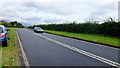
The Chepstow Road
The main A48 between Lydney and Chepstow.
Image: © Jonathan Billinger
Taken: 28 Dec 2006
0.02 miles
3
View to the Severn
Looking south-east from Tidenham beyond the A48 and the estuary to Oldbury Power Station in the distance.
Image: © Jonathan Billinger
Taken: 22 Jul 2010
0.05 miles

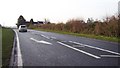
5
A48 towards Lydney
The 100m or so of road within this gridsquare is laid out before the camera.
Image: © Jonathan Billinger
Taken: 25 Sep 2012
0.06 miles
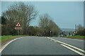
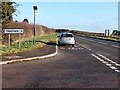
6

The A48 passes the Tidenham junction
The A48, between Chepstow and Lydney, passes the turning for Tidenham Lane. http://www.geograph.org.uk/photo/3280383
Image: © Jaggery
Taken: 1 Jan 2013
0.12 miles
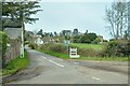
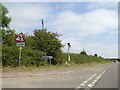
7
Bus stop at the Tidenham junction
Viewed from the A48. The bus stop is on the route from Chepstow to Lydney. There were no buses on this route today, New Year's Day 2013, so this was a good spot to park a car for a few minutes.
Image: © Jaggery
Taken: 1 Jan 2013
0.17 miles
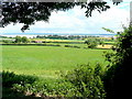
9
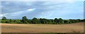
Ploughed fields east of A48
Opposite Day House farm; looking towards the River Severn
Image: © Clint Mann
Taken: 25 Aug 2014
0.17 miles