IMAGES TAKEN NEAR TO
Castleford Hill, CHEPSTOW, NP16 7LE
Introduction
This page details the photographs taken nearby to Castleford Hill, NP16 7LE by members of the Geograph project.
The Geograph project started in 2005 with the aim of publishing, organising and preserving representative images for every square kilometre of Great Britain, Ireland and the Isle of Man.

There are currently over 7.5m images from over14,400 individuals and you can help contribute to the project by visiting https://www.geograph.org.uk
Image Map
Images are licensed for reuse under creativecommons.org/licenses/by-sa/2.0
Notes
- Clicking on the map will re-center to the selected point.
- The higher the marker number, the further away the image location is from the centre of the postcode.
Image Listing (348 Images Found)
Images are licensed for reuse under creativecommons.org/licenses/by-sa/2.0
Image
Details
Distance
1
![A walk around the east bank of the River Wye [59]](https://s3.geograph.org.uk/geophotos/07/36/37/7363767_3e81aa2e_120x120.jpg)
A walk around the east bank of the River Wye [59]
A glimpse of Dean Close, St John's - a co-educational school for children aged 3 to 13. Formerly St John's on the hill School and formerly St John's College. The core building is a country house, once known as Tutshill House. The house was built, probably, in 1806 of rendered brick, lined to simulate ashlar under a roof partly of stone slate and partly of Welsh slate. Many original features and fittings remain. Listed, grade II, with details at: https://historicengland.org.uk/listing/the-list/list-entry/1100283
The walk leaves Chepstow, crosses the River Wye, and ascends through Tutshill, following the long distance Offa’s Dyke Path. A diversion down the Lancaut Walk is taken before returning to rejoin Offa’s Dyke Path to Wintour’s Leap. After crossing Coleford Road, B4228, footpaths and roads are taken through Woodcroft and Tutshill to recross the river and return to the starting point. About 5 miles.
Image: © Michael Dibb
Taken: 3 Sep 2022
0.00 miles
2
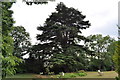
Cedar tree outside Tutshill House (now part of St. Johns on the Hill school)
Image: © Nick Mutton 01329 000000
Taken: 6 Jul 2010
0.04 miles
3
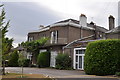
St. Johns on the Hill School, Tutshill
Image: © Nick Mutton 01329 000000
Taken: 6 Jul 2010
0.04 miles
4
Tutshill House (now part of St. Johns on the Hill school)
Image: © Nick Mutton 01329 000000
Taken: 6 Jul 2010
0.04 miles
5
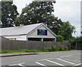
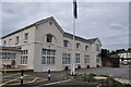
St John's-On-The-Hill School building, Tutshill
A building at the northern edge of St John's-On-The-Hill School viewed across Castleford Hill.
Image: © Jaggery
Taken: 7 Jul 2016
0.05 miles
6

Oakdene path
The Offa's Dyke path makes its way here along the higher banks of the Wye valley. Nice to find the appropriate symbol and house name.
Image: © Neil Owen
Taken: 16 Jun 2014
0.05 miles
7
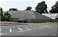
Low pitched roof, Castleford Hill, Tutshill
A building at the northern edge of St John's-On-The-Hill School.
Image: © Jaggery
Taken: 7 Jul 2016
0.05 miles
8
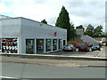
Looking across the original road to Chepstow
Image: © Nick Mutton 01329 000000
Taken: 6 Jul 2010
0.05 miles
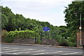
9

Change of direction
The entrance to St John's-on-the-hill school, which seems to have had a rethink about the traffic flow.
Image: © Neil Owen
Taken: 16 Jun 2014
0.05 miles