IMAGES TAKEN NEAR TO
Tidenham, CHEPSTOW, NP16 7JD
Introduction
This page details the photographs taken nearby to NP16 7JD by members of the Geograph project.
The Geograph project started in 2005 with the aim of publishing, organising and preserving representative images for every square kilometre of Great Britain, Ireland and the Isle of Man.

There are currently over 7.5m images from over14,400 individuals and you can help contribute to the project by visiting https://www.geograph.org.uk
Image Map
Images are licensed for reuse under creativecommons.org/licenses/by-sa/2.0
Notes
- Clicking on the map will re-center to the selected point.
- The higher the marker number, the further away the image location is from the centre of the postcode.
Image Listing (19 Images Found)
Images are licensed for reuse under creativecommons.org/licenses/by-sa/2.0
Image
Details
Distance
1
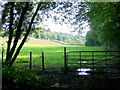
Gate and pasture
View north-east alongside the Wallhope Grove.
Image: © Jonathan Billinger
Taken: 27 Aug 2010
0.02 miles
2
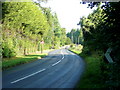
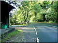
B4228 at Broadrock
Looking north towards Coleford.
Image: © Jonathan Billinger
Taken: 27 Aug 2010
0.05 miles
3
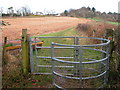
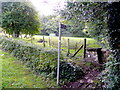
Kissing gate on the edge of Wallhope Grove
A kissing gate on the Offa's Dyke Long Distance Path. The B4228 runs across the skyline. See : Image
Image: © Roy Parkhouse
Taken: 4 Feb 2005
0.08 miles
4
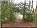
Kissing Gate in Wallhope Grove
On the Offa's Dike Long Distance Path. The path joins the B4228 beyond the stile.
Image: © Roy Parkhouse
Taken: 4 Feb 2005
0.10 miles
5

Stone Stile, Broadrock, B4228
Off the B4228 on Gloucestershire footpath FTM50 looking East. The view looking West is Image This is the "Offa's Dyke Path", there is also a public right of way to the South along the drive to Ashberry House.
Image: © Mr Red
Taken: 17 Jan 2022
0.10 miles
6

Stone Stile, Broadrock, B4228
Off the B4228 on Gloucestershire footpath FTM50 looking SW to the road. The view looking East is Image This is the "Offa's Dyke Path", there is also a public right of way to the South along the drive to Ashberry House.
Image: © Mr Red
Taken: 17 Jan 2022
0.10 miles
7
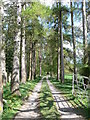
Track to Ashberry House
Taken from the B road which we briefly followed on the Offa's Dyke path.
Image: © John Winder
Taken: 13 Apr 2009
0.10 miles
8
Offa's Dyke Path at Broadrock
The LDF heads north, parallel to the B4228.
Image: © Jonathan Billinger
Taken: 27 Aug 2010
0.11 miles
9
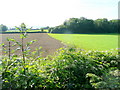
Arable edge
Arable and pastoral rub shoulders south of the B4228 at Boughspring.
Image: © Jonathan Billinger
Taken: 27 Aug 2010
0.13 miles
10
B4228 at Broadrock 2
A bus shelter on the Chepstow-bound side.
Image: © Jonathan Billinger
Taken: 27 Aug 2010
0.14 miles