IMAGES TAKEN NEAR TO
Wyvern Road, CHEPSTOW, NP16 7HR
Introduction
This page details the photographs taken nearby to Wyvern Road, NP16 7HR by members of the Geograph project.
The Geograph project started in 2005 with the aim of publishing, organising and preserving representative images for every square kilometre of Great Britain, Ireland and the Isle of Man.

There are currently over 7.5m images from over14,400 individuals and you can help contribute to the project by visiting https://www.geograph.org.uk
Image Map
Images are licensed for reuse under creativecommons.org/licenses/by-sa/2.0
Notes
- Clicking on the map will re-center to the selected point.
- The higher the marker number, the further away the image location is from the centre of the postcode.
Image Listing (109 Images Found)
Images are licensed for reuse under creativecommons.org/licenses/by-sa/2.0
Image
Details
Distance
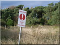
1
Warning sign, Beachley coastal path
The coastal path runs along the fenced-off southern perimeter of Beachley Barracks. The signs notifies walkers that this is MoD (Ministry of Defence) land and to keep to the path.
Image: © Jaggery
Taken: 17 Sep 2010
0.05 miles
2
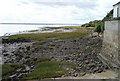
Coast south of Severn Bridge, Beachley
Technically this is a river bank, but as the Severn is more than one mile (1.6km) wide at this point, perhaps coast is the better word.
Image: © Jaggery
Taken: 17 Sep 2010
0.07 miles
3
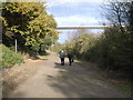
Beachley Point - footpath under M48 Severn Bridge
Image: © Nick Mutton 01329 000000
Taken: 11 Nov 2007
0.07 miles
6
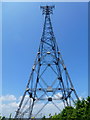
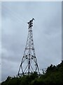
Beachley pylon
The western pylon of the pair that carry electricity over the Severn estuary parallel to the old Severn Bridge.
Image: © Jonathan Billinger
Taken: 19 Jun 2013
0.08 miles
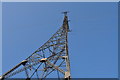
7
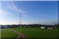
Pylon behind Beachley Barracks Sports Grounds
The tall pylon supports the north-west end of the Aust Severn Powerline Crossing (partner at Image)
Image: © Tim Heaton
Taken: 11 Feb 2016
0.08 miles
8
Pylon on Beachley Point
The powerline is part of the national Grid. At 1610 metres long, this is the longest powerline span in the UK. The pylon is 149 metres tall.
Image: © Bikeboy
Taken: 8 Apr 2014
0.08 miles
9
![Beachley village [3]](https://s1.geograph.org.uk/geophotos/07/35/07/7350793_2e81b1b0_120x120.jpg)
Beachley village [3]
Looking southwest along the shore from the slipway of the Aust Ferry.
Beachley is a village in Gloucestershire, located on a peninsula at the confluence of the River Wye and the River Severn, some 2 miles southeast of Chepstow. Here the Severn Bridge ends and the bridge over the River Wye begins, both bridges carry the M48 motorway, formerly the M4. Prior to the construction of the bridge, Beachley was a ferry port from where the Aust Ferry operated until 1966. The village is home to an infantry barracks, occupying the site of the former Army Apprentices College.
Image: © Michael Dibb
Taken: 31 Aug 2022
0.08 miles
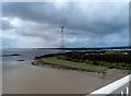
10
Looking up to pylon at Beachley Point
Image: © Nick Mutton 01329 000000
Taken: 7 Mar 2010
0.09 miles