IMAGES TAKEN NEAR TO
Sycamore Grove, CHEPSTOW, NP16 7FJ
Introduction
This page details the photographs taken nearby to Sycamore Grove, NP16 7FJ by members of the Geograph project.
The Geograph project started in 2005 with the aim of publishing, organising and preserving representative images for every square kilometre of Great Britain, Ireland and the Isle of Man.

There are currently over 7.5m images from over14,400 individuals and you can help contribute to the project by visiting https://www.geograph.org.uk
Image Map
Images are licensed for reuse under creativecommons.org/licenses/by-sa/2.0
Notes
- Clicking on the map will re-center to the selected point.
- The higher the marker number, the further away the image location is from the centre of the postcode.
Image Listing (56 Images Found)
Images are licensed for reuse under creativecommons.org/licenses/by-sa/2.0
Image
Details
Distance
1
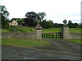
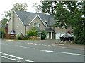
Entrance to Wirewoods Manor House, Elm Road
Image: © Nick Mutton 01329 000000
Taken: 14 Sep 2007
0.07 miles
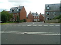
2
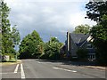
Gloucester Road, Tutshill, at the junction with Elm Road
Image: © Ruth Sharville
Taken: 6 Jun 2010
0.09 miles
3
![A walk around the east bank of the River Wye [53]](https://s1.geograph.org.uk/geophotos/07/36/37/7363757_15e3b1e3_120x120.jpg)
A walk around the east bank of the River Wye [53]
The route follows this path as it leaves Gloucester Road.
The walk leaves Chepstow, crosses the River Wye, and ascends through Tutshill, following the long distance Offa’s Dyke Path. A diversion down the Lancaut Walk is taken before returning to rejoin Offa’s Dyke Path to Wintour’s Leap. After crossing Coleford Road, B4228, footpaths and roads are taken through Woodcroft and Tutshill to recross the river and return to the starting point. About 5 miles.
Image: © Michael Dibb
Taken: 3 Sep 2022
0.09 miles
4
Looking up towards Cross Keys Pub
Image: © Nick Mutton 01329 000000
Taken: 14 Sep 2007
0.10 miles
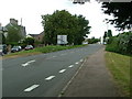
5

Tutshill Village sign on B4228
Image: © Nick Mutton 01329 000000
Taken: 14 Sep 2007
0.11 miles
6
Elm Road and Elm Close, Tutshill
Viewed across Gloucester Road. Straight ahead from Elm Road, sharp left (behind the No Through Road sign next to the tree on the left) for Elm Close.
Image: © Jaggery
Taken: 17 Sep 2010
0.11 miles
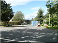
7
Entrance to Piermont Drive
Piermont Drive is one of two housing developments built on the old site of Bigstone House.
Image: © Nick Mutton 01329 000000
Taken: 14 Sep 2007
0.11 miles
8
Looking in to Bigstone Meadow from B4228
Image: © Nick Mutton 01329 000000
Taken: 14 Sep 2007
0.12 miles
9
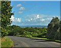
Road Near Tutshill
The River Severn in the far distance
Image: © Deborah Tilley
Taken: 12 Sep 2015
0.12 miles
10
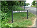
Bigstone Meadow road sign
Bigstone Meadow residents have been waiting for nearly 3 years for the Forest of Dean District Council to put these signs up.
Image: © Nick Mutton 01329 000000
Taken: 14 Sep 2007
0.12 miles