IMAGES TAKEN NEAR TO
Birch Grove, CHEPSTOW, NP16 7FH
Introduction
This page details the photographs taken nearby to Birch Grove, NP16 7FH by members of the Geograph project.
The Geograph project started in 2005 with the aim of publishing, organising and preserving representative images for every square kilometre of Great Britain, Ireland and the Isle of Man.

There are currently over 7.5m images from over14,400 individuals and you can help contribute to the project by visiting https://www.geograph.org.uk
Image Map
Images are licensed for reuse under creativecommons.org/licenses/by-sa/2.0
Notes
- Clicking on the map will re-center to the selected point.
- The higher the marker number, the further away the image location is from the centre of the postcode.
Image Listing (44 Images Found)
Images are licensed for reuse under creativecommons.org/licenses/by-sa/2.0
Image
Details
Distance
1
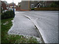
Hail & ice storm in Tutshill
This was taken at 11:10am on 1/12/2008 when ice and hail just covered the roads in Tutshill. The ice simply froze and made driving hazardous. Bad weather is forecast all day today.
Image: © Nick Mutton 01329 000000
Taken: 1 Dec 2007
0.04 miles
2
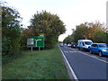
A48 towards Gloucester
Nearing the junction with the B4228. Heavy traffic coming into Chepstow.
Image: © JThomas
Taken: 17 Oct 2019
0.04 miles
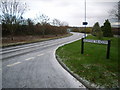
3
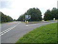
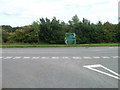
Junction of B4228 and A48, Tutshill
Near the eastern edge of Tutshill, the B4228 (Gloucester Road), on the right, climbs away from the A48.
Image: © Jaggery
Taken: 17 Sep 2010
0.05 miles
4
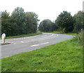
B4228 curves away from A48, near Tutshill
Gloucester Road (B4228) climbs away from the A48 towards the eastern edge of Tutshill.
Image: © Jaggery
Taken: 17 Sep 2010
0.05 miles
5
Hail & ice storm in Tutshill
This was taken at 11:10am on 1/12/2008 when ice and hail just covered the roads in Tutshill. The ice simply froze and made driving hazardous. Bad weather is forecast all day today.
Image: © Nick Mutton 01329 000000
Taken: 1 Dec 2007
0.05 miles
6
Hail & ice storm in Tutshill
This was taken at 11:10am on 1/12/2008 when ice and hail just covered the roads in Tutshill. The ice simply froze and made driving hazardous. Bad weather is forecast all day today.
Image: © Nick Mutton 01329 000000
Taken: 1 Dec 2007
0.05 miles
7
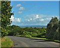
Road Near Tutshill
The River Severn in the far distance
Image: © Deborah Tilley
Taken: 12 Sep 2015
0.06 miles
8
Junction of B4228 & Bigstone Meadow
Image: © Nick Mutton 01329 000000
Taken: 14 Sep 2007
0.06 miles
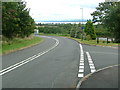
9
Near Tutshill, B4228 reaches A48
Looking along the B4228 across the A48. Right for Chepstow and the M4, left for Gloucester, and Woolaston (4 miles) Alvington (6 miles) Lydney (8 miles).
Image: © Jaggery
Taken: 17 Sep 2010
0.07 miles
10
Bigstone Meadow, featuring Wye View House
This is a view within Bigstone Meadow - still not featured on OS maps as only built in 2004.
Image: © Nick Mutton 01329 000000
Taken: 14 Sep 2007
0.07 miles