IMAGES TAKEN NEAR TO
Gloucester Road, CHEPSTOW, NP16 7DE
Introduction
This page details the photographs taken nearby to Gloucester Road, NP16 7DE by members of the Geograph project.
The Geograph project started in 2005 with the aim of publishing, organising and preserving representative images for every square kilometre of Great Britain, Ireland and the Isle of Man.

There are currently over 7.5m images from over14,400 individuals and you can help contribute to the project by visiting https://www.geograph.org.uk
Image Map
Images are licensed for reuse under creativecommons.org/licenses/by-sa/2.0
Notes
- Clicking on the map will re-center to the selected point.
- The higher the marker number, the further away the image location is from the centre of the postcode.
Image Listing (122 Images Found)
Images are licensed for reuse under creativecommons.org/licenses/by-sa/2.0
Image
Details
Distance
1
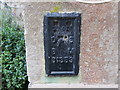
Ordnance Survey Flush Bracket S1359
This can be found on the wall of a private dwelling in Gloucester Road, Tutshill.
For more detail see : http://www.bench-marks.org.uk/bm16017
Image: © Peter Wood
Taken: 16 Oct 2016
0.04 miles
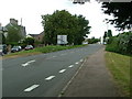
2
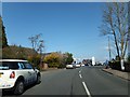
Gloucester Road, Tutshill
The road close to the Fiat dealers and garage
Image: © David Smith
Taken: 16 Apr 2013
0.04 miles
4
Elm Road and Elm Close, Tutshill
Viewed across Gloucester Road. Straight ahead from Elm Road, sharp left (behind the No Through Road sign next to the tree on the left) for Elm Close.
Image: © Jaggery
Taken: 17 Sep 2010
0.04 miles
5
Looking up towards Cross Keys Pub
Image: © Nick Mutton 01329 000000
Taken: 14 Sep 2007
0.06 miles
7
![A walk around the east bank of the River Wye [53]](https://s1.geograph.org.uk/geophotos/07/36/37/7363757_15e3b1e3_120x120.jpg)
A walk around the east bank of the River Wye [53]
The route follows this path as it leaves Gloucester Road.
The walk leaves Chepstow, crosses the River Wye, and ascends through Tutshill, following the long distance Offa’s Dyke Path. A diversion down the Lancaut Walk is taken before returning to rejoin Offa’s Dyke Path to Wintour’s Leap. After crossing Coleford Road, B4228, footpaths and roads are taken through Woodcroft and Tutshill to recross the river and return to the starting point. About 5 miles.
Image: © Michael Dibb
Taken: 3 Sep 2022
0.08 miles
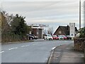
8
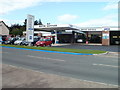
Motor Services, Tutshill
Located on Gloucester Road. Fiat dealers, also selling and servicing all makes. The premises are also an MoT test centre.
Image: © Jaggery
Taken: 17 Sep 2010
0.08 miles
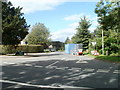
9
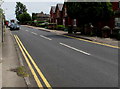
End of the no parking zone, Gloucester Road, Tutshill
The double yellow lines mark the zone where parking is illegal at any time.
Image: © Jaggery
Taken: 7 Jul 2016
0.09 miles
10
Milestone outside The Cross Keys pub, Tutshill
This is an original milestone outside the pub.
Image: © Nick Mutton 01329 000000
Taken: 18 Sep 2007
0.09 miles