IMAGES TAKEN NEAR TO
Newton Manor, CHEPSTOW, NP16 6UA
Introduction
This page details the photographs taken nearby to Newton Manor, NP16 6UA by members of the Geograph project.
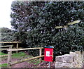
The Geograph project started in 2005 with the aim of publishing, organising and preserving representative images for every square kilometre of Great Britain, Ireland and the Isle of Man.

There are currently over 7.5m images from over14,400 individuals and you can help contribute to the project by visiting https://www.geograph.org.uk
Image Map
Images are licensed for reuse under creativecommons.org/licenses/by-sa/2.0
Notes
- Clicking on the map will re-center to the selected point.
- The higher the marker number, the further away the image location is from the centre of the postcode.
Image Listing (145 Images Found)
Images are licensed for reuse under creativecommons.org/licenses/by-sa/2.0
Image
Details
Distance
1
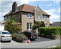
Former police station, Shirenewton
The stone above the doorway of what is now a private residence in Earlswood Road shows POLICE STATION 1911.
Image: © Jaggery
Taken: 14 Jul 2011
0.05 miles
2
Friends' Burial Ground, Shirenewton
Located on the east side of Ditch Hill Lane. The entrance gate http://www.geograph.org.uk/photo/3184737 shows the year 1700.
The Society of Friends, or Quakers, were active in Shirenewton from the 17th century.
Their founder George Fox stayed in the village and preached at a meeting before continuing
his journey through South Wales. A Meeting House was built in 1730
in the centre of the village, and was used until closure in 1853.
Image: © Jaggery
Taken: 14 Jul 2011
0.05 miles
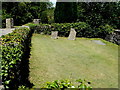
3
Entrance gate to Friends' Burial Ground, Shirenewton
View from Ditch Hill Lane. The black gate bears the inscription Friends Burial Ground 1700.
It leads to a few graves in a very small burial ground. http://www.geograph.org.uk/photo/3184741
The Society of Friends, or Quakers, were active in Shirenewton from the 17th century.
Their founder George Fox stayed in the village and preached at a meeting before continuing
his journey through South Wales. A Meeting House was built in 1730
in the centre of the village, and was used until closure in 1853.
Image: © Jaggery
Taken: 14 Jul 2011
0.05 miles
4
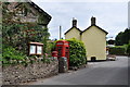
North along Ditch Hill Lane, Shirenewton
The red phonebox https://www.geograph.org.uk/photo/5652694 is outside The Old Post Office.
Image: © Jaggery
Taken: 14 Jan 2018
0.06 miles
5
Public footpath signpost in Shirenewton
Alongside Earlswood Road behind a dog waste bin. The signpost shows left for Dinham 1.6 km.
Right for Coxe's Well 0.2km. No equivalents in miles or yards are shown.
Image: © Jaggery
Taken: 14 Jan 2018
0.06 miles
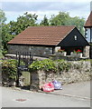
6
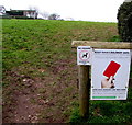
Keep your children safe - Give dog fouling the red card, Shirenewton
The notice faces Earlswood Road at the edge of a public footpath to Dinham.
The smaller notice shows NO FOULING - MAXIMUM FINE £1000.
Dog fouling can cause serious harm to children's health.
Image: © Jaggery
Taken: 14 Jan 2018
0.06 miles
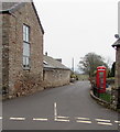
7
Shirenewton telephone kiosk
Image: © Nick Mutton 01329 000000
Taken: 19 Jul 2010
0.06 miles
8
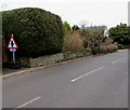
Warning sign and cycle route 42 sign, Earlswood Road, Shirenewton, Monmouthshire
The triangular sign warns that a minor crossroads junction is ahead. The small rectangular sign showing 42 depicts a bicycle. In January 2018, the Sustrans website states that National Route 42 of the National Cycle Network will run west from Gloucester through Cinderford to Chepstow and then north through Abergavenny to join National Route 8 at Glasbury with the option of passing through Hay-on-Wye.
Image: © Jaggery
Taken: 14 Jan 2018
0.07 miles
9
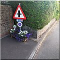
Queen's Platinum Jubilee 2022 floral display, Shirenewton
Alongside Earlswood Road. The flowers were donated by Chepstow Garden Centre.
Image: © Jaggery
Taken: 17 Jul 2022
0.07 miles
10
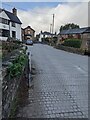
From Crick Road to Earlswood Road, Shirenewton
Opposite the Ditch Hill Lane junction https://www.geograph.org.uk/photo/6977810 Crick Road becomes Earlswood Road. Newton Lodge https://www.geograph.org.uk/photo/3179282 is on the left.
Image: © Jaggery
Taken: 26 Sep 2021
0.07 miles