IMAGES TAKEN NEAR TO
Tintern, CHEPSTOW, NP16 6TF
Introduction
This page details the photographs taken nearby to NP16 6TF by members of the Geograph project.
The Geograph project started in 2005 with the aim of publishing, organising and preserving representative images for every square kilometre of Great Britain, Ireland and the Isle of Man.

There are currently over 7.5m images from over14,400 individuals and you can help contribute to the project by visiting https://www.geograph.org.uk
Image Map
Images are licensed for reuse under creativecommons.org/licenses/by-sa/2.0
Notes
- Clicking on the map will re-center to the selected point.
- The higher the marker number, the further away the image location is from the centre of the postcode.
Image Listing (320 Images Found)
Images are licensed for reuse under creativecommons.org/licenses/by-sa/2.0
Image
Details
Distance
1
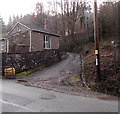
Lane past the western edge of the Old School House, Tintern
A public footpath sign on the right points along the lane which ascends from Forge Road past the Old School House. http://www.geograph.org.uk/photo/3819052.
Image: © Jaggery
Taken: 19 Jan 2014
0.02 miles
2

Old School House, Forge Road, Tintern
Now in residential use. Kelly's Directory of Monmouthshire (1901 edition) stated
that this was The National School for boys, girls & infants. Average attendance was 124.
Image: © Jaggery
Taken: 16 Aug 2017
0.03 miles
3
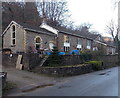
Old School House, Tintern
Viewed across Forge Road. Now in residential use. Kelly's Directory of Monmouthshire 1901 stated that this was The National School for boys, girls & infants. Average attendance was 124.
Image: © Jaggery
Taken: 19 Jan 2014
0.03 miles
4
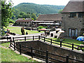
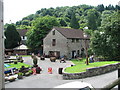
Tintern Abbey Mill
The water that once drove the mill came from the Angiddy, which flows through the structure in the foreground.
Image: © Roy Parkhouse
Taken: 1 Jul 2006
0.04 miles
5
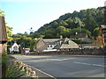
Tintern - The Royal George Hotel
Viewed from across the A466, outside Abbey Mill.
Image: © Roy Parkhouse
Taken: 27 Sep 2005
0.04 miles
6
Abbey Mill shop
The car park is to the left of the photograph. The shop fronts the A466.
Image: © Roy Parkhouse
Taken: 28 Jul 2007
0.04 miles
7
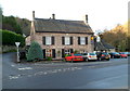
The Royal George Hotel, Tintern
Viewed across Main Road (the A466). The independently owned and operated hotel is a franchisee of Best Western, the world's largest hotel chain.
Image: © Jaggery
Taken: 27 Nov 2011
0.04 miles
8
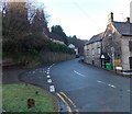
Eastern end of Forge Road, Tintern
Forge Road heads WSW away from the A466 past The Royal George Hotel. http://www.geograph.org.uk/photo/3819022
Image: © Jaggery
Taken: 19 Jan 2014
0.05 miles
9
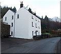
Crown Lodge, Tintern
The 3-storey house in Forge Road was Grade II listed in 2000.
Image: © Jaggery
Taken: 19 Jan 2014
0.05 miles
10

Grade II listed Crown Lodge, Forge Road, Tintern
The three-storey house dating from c1800 was Grade II listed in 2000.
Image: © Jaggery
Taken: 16 Aug 2017
0.05 miles