IMAGES TAKEN NEAR TO
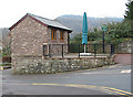
Lower Leytons, CHEPSTOW, NP16 6SY
Introduction
This page details the photographs taken nearby to Lower Leytons, NP16 6SY by members of the Geograph project.
The Geograph project started in 2005 with the aim of publishing, organising and preserving representative images for every square kilometre of Great Britain, Ireland and the Isle of Man.

There are currently over 7.5m images from over14,400 individuals and you can help contribute to the project by visiting https://www.geograph.org.uk
Image Map
Images are licensed for reuse under creativecommons.org/licenses/by-sa/2.0
Notes
- Clicking on the map will re-center to the selected point.
- The higher the marker number, the further away the image location is from the centre of the postcode.
Image Listing (580 Images Found)
Images are licensed for reuse under creativecommons.org/licenses/by-sa/2.0
Image
Details
Distance
1
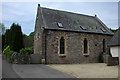
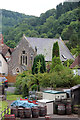
Converted chapel in Tintern
Mae House, a converted chapel in Tintern.
Image: © Philip Halling
Taken: 10 May 2008
0.01 miles
2
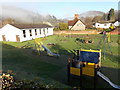
Children's play area, Tintern
On the north side of the A466, the main road through the village.
Image: © Jaggery
Taken: 19 Jan 2014
0.02 miles
3
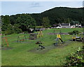
Children's playground in Tintern
On the north side of the A466, the main road through the village. A sports field is behind the playground.
Image: © Jaggery
Taken: 14 Aug 2014
0.02 miles
4
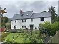
Quay House
Cottage on the bank of the River Wye at Tintern.
Image: © Alan Hughes
Taken: 15 Jul 2020
0.02 miles
6
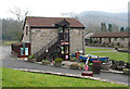
Abbey Mill Boat House
One of several shops in the Abbey Mill complex, sometimes known as the Wye valley centre.
Image: © Pauline E
Taken: 24 Feb 2008
0.02 miles
7
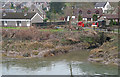
Angiddy joins the Wye at Abbey Mill
The Angiddy is named as a river, a brook and a stream, depending on the source. It was used to power the mill which served Tintern Abbey. The mill area is now a small complex of shops. Picture taken from the old railway bridge, now a footbridge.
Image: © Pauline E
Taken: 24 Feb 2008
0.02 miles
8
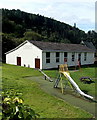
Tintern Village Hall
Viewed across a children's playground from the edge of the A466, the main road
through the village. The foundation stone was laid on May 1st 1974. The hall's
regular users are local societies and organisations. The hall is also available for hire.
Image: © Jaggery
Taken: 14 Aug 2014
0.03 miles
9
Small coffee house, Tintern
Closed on this dull, February day.
Image: © Pauline E
Taken: 24 Feb 2008
0.03 miles
10
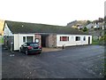
Tintern Village Hall
Set back from the north side of the A466, the main road through the village.
The foundation stone was laid on May 1st 1974. The hall's regular users are local societies and organisations. The facilities are also available for hire.
Image: © Jaggery
Taken: 27 Nov 2011
0.03 miles