IMAGES TAKEN NEAR TO
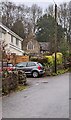
Well Lane, CHEPSTOW, NP16 6RA
Introduction
This page details the photographs taken nearby to Well Lane, NP16 6RA by members of the Geograph project.
The Geograph project started in 2005 with the aim of publishing, organising and preserving representative images for every square kilometre of Great Britain, Ireland and the Isle of Man.

There are currently over 7.5m images from over14,400 individuals and you can help contribute to the project by visiting https://www.geograph.org.uk
Image Map
Images are licensed for reuse under creativecommons.org/licenses/by-sa/2.0
Notes
- Clicking on the map will re-center to the selected point.
- The higher the marker number, the further away the image location is from the centre of the postcode.
Image Listing (128 Images Found)
Images are licensed for reuse under creativecommons.org/licenses/by-sa/2.0
Image
Details
Distance
1

Village Farm House, Llanvair Discoed
Viewed from Well Lane. The name sign on the corner (centre right) shows Village Farm House.
The name sign on the left shows The Barn.
Image: © Jaggery
Taken: 15 Feb 2012
0.01 miles
2
Trio of drain covers on Well Lane, Llanvair Discoed
These three drains, and another three nearby, empty into a drainage channel on the side of Well Lane.
Image: © Jaggery
Taken: 15 Feb 2012
0.03 miles
3

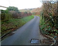
Well Lane NNW of Redlands, Llanvair Discoed
The entrance to Redlands is on the left.
Image: © Jaggery
Taken: 15 Feb 2012
0.04 miles
4
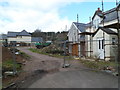
Fenced-off area, Well Lane, Llanvair Discoed
Houses were being built (or rebuilt) on the west side of the lane at the February 2012 date of this view.
Image: © Jaggery
Taken: 15 Feb 2012
0.06 miles
5

Well Lane, Llanvair Discoed
This is the southern part of a 400 metre long residential lane.
Image: © Jaggery
Taken: 15 Feb 2012
0.07 miles
6
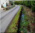
Well Lane drainage channel, Llanvair Discoed
Along the east side of the lane.
Image: © Jaggery
Taken: 15 Feb 2012
0.07 miles
7
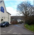
Well Lane, Llanvair Discoed
Viewed past the edge of the Woodlands Tavern. http://www.geograph.org.uk/photo/3850181
Image: © Jaggery
Taken: 15 Feb 2012
0.08 miles
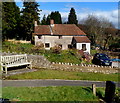
8
Towards the village church, Llanvair Discoed
St Mary's Church https://www.geograph.org.uk/photo/3919578 in the Church in Wales
Diocese of Monmouth is in the background.
Image: © Jaggery
Taken: 26 Dec 2021
0.08 miles
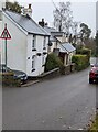
9
Bramble Cottage, Llanvair Discoed
Viewed from St Mary's http://www.geograph.org.uk/photo/3919541 churchyard.
Image: © Jaggery
Taken: 15 Feb 2012
0.09 miles
10
Warning sign - road narrows ahead, Llanvair Discoed
Viewed in December 2021. The sign was not here in a June 2011 Google Street View.
Image: © Jaggery
Taken: 26 Dec 2021
0.10 miles