IMAGES TAKEN NEAR TO
Redd Landes, CHEPSTOW, NP16 6QP
Introduction
This page details the photographs taken nearby to Redd Landes, NP16 6QP by members of the Geograph project.
The Geograph project started in 2005 with the aim of publishing, organising and preserving representative images for every square kilometre of Great Britain, Ireland and the Isle of Man.

There are currently over 7.5m images from over14,400 individuals and you can help contribute to the project by visiting https://www.geograph.org.uk
Image Map
Images are licensed for reuse under creativecommons.org/licenses/by-sa/2.0
Notes
- Clicking on the map will re-center to the selected point.
- The higher the marker number, the further away the image location is from the centre of the postcode.
Image Listing (145 Images Found)
Images are licensed for reuse under creativecommons.org/licenses/by-sa/2.0
Image
Details
Distance
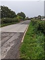
1
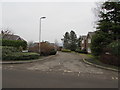
Redd Landes, Shirenewton
Cul-de-sac on the north side of Earlswood Road. The name Redd Landes appears to be unique in the UK.
Image: © Jaggery
Taken: 14 Jan 2018
0.01 miles
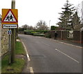
2
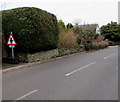
Warning sign and cycle route 42 sign, Earlswood Road, Shirenewton, Monmouthshire
The triangular sign warns that a minor crossroads junction is ahead. The small rectangular sign showing 42 depicts a bicycle. In January 2018, the Sustrans website states that National Route 42 of the National Cycle Network will run west from Gloucester through Cinderford to Chepstow and then north through Abergavenny to join National Route 8 at Glasbury with the option of passing through Hay-on-Wye.
Image: © Jaggery
Taken: 14 Jan 2018
0.02 miles
3
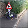
Queen's Platinum Jubilee 2022 floral display, Shirenewton
Alongside Earlswood Road. The flowers were donated by Chepstow Garden Centre.
Image: © Jaggery
Taken: 17 Jul 2022
0.02 miles
4
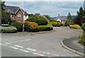
Redd Landes, Shirenewton
Short cul-de-sac on the north side of Earlswood Road.
The unusual street name Redd Landes appears to be unique in the UK.
Image: © Jaggery
Taken: 14 Jul 2011
0.02 miles
5
East along Earlswood Road, Shirenewton
Towards the centre of Shirenewton.
Image: © Jaggery
Taken: 26 Sep 2021
0.03 miles
6
Warning sign - playground, Shirenewton
Facing Earlswood Road on the approach to this https://www.geograph.org.uk/photo/5652529 playground.
The small rectangular sign shows that this road is part of National Cycle Network Route 42.
Image: © Jaggery
Taken: 14 Jan 2018
0.03 miles
7
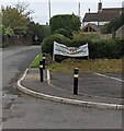
Banner alongside Earlswood Road, Shirenewton
"Help our children walk and cycle to school.
Please keep to our 20mph speed limits"
Image: © Jaggery
Taken: 26 Sep 2021
0.03 miles
8
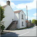
Steps to nowhere, Upper House, Shirenewton
Now a private residence, Upper House was formerly licensed premises, from c1847.
Image: © Jaggery
Taken: 14 Jul 2011
0.03 miles
9
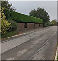
Long evergreen hedge in Shirenewton
Viewed across Earlswood Road in September 2021.
Image: © Jaggery
Taken: 26 Sep 2021
0.04 miles
10
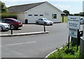
Shirenewton recreation area
Located in the west of the village, on the south side of Earlswood Road.
The facilities include a large field with football goals, and an adjacent tennis court.
The building, with a small kitchen, bathroom facilities and cloakroom, is available for hire.
Image: © Jaggery
Taken: 14 Jul 2011
0.04 miles