IMAGES TAKEN NEAR TO
Devauden, CHEPSTOW, NP16 6PB
Introduction
This page details the photographs taken nearby to NP16 6PB by members of the Geograph project.
The Geograph project started in 2005 with the aim of publishing, organising and preserving representative images for every square kilometre of Great Britain, Ireland and the Isle of Man.

There are currently over 7.5m images from over14,400 individuals and you can help contribute to the project by visiting https://www.geograph.org.uk
Image Map
Images are licensed for reuse under creativecommons.org/licenses/by-sa/2.0
Notes
- Clicking on the map will re-center to the selected point.
- The higher the marker number, the further away the image location is from the centre of the postcode.
Image Listing (31 Images Found)
Images are licensed for reuse under creativecommons.org/licenses/by-sa/2.0
Image
Details
Distance
1
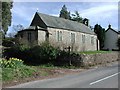
Devauden, Church of St James
http://www.churchcrawler.pwp.blueyonder.co.uk/churchcrawler/gwent.htm
Image: © ChurchCrawler
Taken: 21 Mar 2002
0.12 miles
2
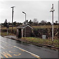
Weather station, Devauden
Located alongside the main road through the village, though "weather station" seems an exaggeration since the instrumentation appears to be limited to a temperature sensor on top of the pole. I do not know the function of the protuberance between the sensor and the two CCTV cameras.
Image: © Jaggery
Taken: 13 Jan 2014
0.12 miles
3
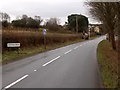
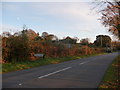
Northern boundary of Devauden
The B4293 passes the boundary sign for Devauden, a small village in upland Monmouthshire.
The road here is about 250 metres (c820 ft) above sea level.
Image: © Jaggery
Taken: 13 Jan 2014
0.13 miles
4
Devauden bus shelters
Alongside the B4293 in the north of the village.
Image: © Jaggery
Taken: 13 Jan 2014
0.13 miles
5
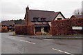
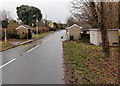
Eastern edge of Churchfields, Devauden
Viewed from the B4293, the main road through the village.
Churchfields is a cul-de-sac of 18 modern detached houses.
Image: © Jaggery
Taken: 13 Jan 2014
0.13 miles
6
Devauden village sign
One of Monmouthshire's prettiest villages is denoted by this sign when approaching from the north.
Image: © Jeremy Bolwell
Taken: 5 Nov 2011
0.13 miles
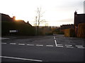
7
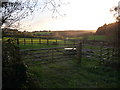
Monmouthshire countryside near Devauden
Quiet fields near the village under a setting November sun.
Image: © Jeremy Bolwell
Taken: 5 Nov 2011
0.13 miles
8
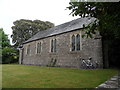
Church of St James Devauden
Churches and chapels (no 17). It began as Devauden school. Built in 1814, it was the first National School in Monmouthshire. The school was converted to a church in 1827.
Image: © Andy Stott
Taken: 1 Jun 2012
0.14 miles
9
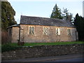
St. James' church, Devauden
A lovely, small village church. I understand that it gets packed at Christmas Eve with local residents and holds a popular service of traditional carols. Must be a special spot up here at that special time.
Image: © Jeremy Bolwell
Taken: 5 Nov 2011
0.14 miles
10
The entrance to Churchfields estate, Devauden
I can remember when these executive style homes were built. There are now proposals to build more homes beyond them, extending the existing estate.
Image: © Jeremy Bolwell
Taken: 5 Nov 2011
0.14 miles