IMAGES TAKEN NEAR TO
Devauden, CHEPSTOW, NP16 6NN
Introduction
This page details the photographs taken nearby to NP16 6NN by members of the Geograph project.
The Geograph project started in 2005 with the aim of publishing, organising and preserving representative images for every square kilometre of Great Britain, Ireland and the Isle of Man.

There are currently over 7.5m images from over14,400 individuals and you can help contribute to the project by visiting https://www.geograph.org.uk
Image Map
Images are licensed for reuse under creativecommons.org/licenses/by-sa/2.0
Notes
- Clicking on the map will re-center to the selected point.
- The higher the marker number, the further away the image location is from the centre of the postcode.
Image Listing (33 Images Found)
Images are licensed for reuse under creativecommons.org/licenses/by-sa/2.0
Image
Details
Distance
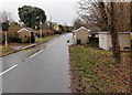
1
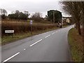
Northern boundary of Devauden
The B4293 passes the boundary sign for Devauden, a small village in upland Monmouthshire.
The road here is about 250 metres (c820 ft) above sea level.
Image: © Jaggery
Taken: 13 Jan 2014
0.06 miles
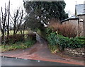
2
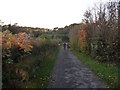
Lane near Devauden village
This lane runs down to the main road through the village.
Image: © Jeremy Bolwell
Taken: 5 Nov 2011
0.07 miles
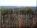
3
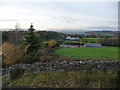
View from the water tank near Devauden
This view looks towards Abergavenny, the Usk valley and the southern Black Mountains. What a view.
Image: © Jeremy Bolwell
Taken: 5 Nov 2011
0.07 miles
4
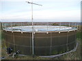
The Welsh Water water tank near Devauden
The best sited water tank that I have ever seen. What a spot. Beautiful 360 degree views.
Image: © Jeremy Bolwell
Taken: 5 Nov 2011
0.08 miles
5
An old footpath near Devauden village
What is nicer than walking the dog before dusk in a village high in the Monmouthshire hills?
Image: © Jeremy Bolwell
Taken: 5 Nov 2011
0.08 miles
6
Rough pasture near Devauden, Monmouthshire
Looking from the water tank towards the Wye Valley. What a spot.
Image: © Jeremy Bolwell
Taken: 5 Nov 2011
0.08 miles
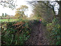
7
Bridleway in Devauden
The bridleway heads away from the B4293 past the edge of the village church. http://www.geograph.org.uk/photo/3813892 It seems certain that the speed camera symbol on the left applies to traffic on the main road, not the bridleway!
Image: © Jaggery
Taken: 13 Jan 2014
0.09 miles
8
Weather station, Devauden
Located alongside the main road through the village, though "weather station" seems an exaggeration since the instrumentation appears to be limited to a temperature sensor on top of the pole. I do not know the function of the protuberance between the sensor and the two CCTV cameras.
Image: © Jaggery
Taken: 13 Jan 2014
0.09 miles
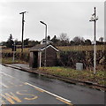
9
Devauden bus shelters
Alongside the B4293 in the north of the village.
Image: © Jaggery
Taken: 13 Jan 2014
0.10 miles
10
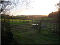
Monmouthshire countryside near Devauden
Quiet fields near the village under a setting November sun.
Image: © Jeremy Bolwell
Taken: 5 Nov 2011
0.10 miles