IMAGES TAKEN NEAR TO
Mounton Court, CHEPSTOW, NP16 6FF
Introduction
This page details the photographs taken nearby to Mounton Court, NP16 6FF by members of the Geograph project.
The Geograph project started in 2005 with the aim of publishing, organising and preserving representative images for every square kilometre of Great Britain, Ireland and the Isle of Man.

There are currently over 7.5m images from over14,400 individuals and you can help contribute to the project by visiting https://www.geograph.org.uk
Image Map
Images are licensed for reuse under creativecommons.org/licenses/by-sa/2.0
Notes
- Clicking on the map will re-center to the selected point.
- The higher the marker number, the further away the image location is from the centre of the postcode.
Image Listing (99 Images Found)
Images are licensed for reuse under creativecommons.org/licenses/by-sa/2.0
Image
Details
Distance
1
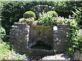
Holy Well on Spout Hill
Just outside Shirenewton is a small water source on Spout Hill. It does not appears to be an ancient source nor associated with any particular saint. Following restoration the well and surrounds were rebuilt in 2000. Fortunately, the benchmark on the lower stone remains. See https://www.bench-marks.org.uk/bm205167 for the entry in the Benchmark Database.
Image: © Neil Owen
Taken: 13 Jun 2023
0.05 miles
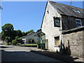
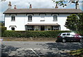
3
The Tan House pub to let, Shirenewton
This July 2011 view shows that the Tan House pub was to let.
Several letters are missing from the TAN HOUSE name on the wall.
Image: © Jaggery
Taken: 14 Jul 2011
0.09 miles
4
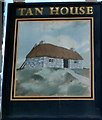
Tan House pub sign, Shirenewton
The sign hangs from a bracket here. http://www.geograph.org.uk/photo/3185192
Image: © Jaggery
Taken: 14 Jul 2011
0.09 miles
5
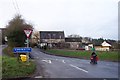
Bus shelter outside the Tan House, Shirenewton
The bus stop and shelter are on the corner of Tan House Court, at the edge of the Tan House pub. http://www.geograph.org.uk/photo/3185192
Image: © Jaggery
Taken: 14 Jul 2011
0.09 miles
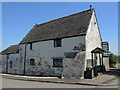
6
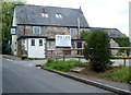
The Tan House, Shirenewton
Having been the subject of a battle over ownership about a decade ago, the pub was open until fairly recently. It has the look of a pub that has finally closed now.
Image: © Neil Owen
Taken: 13 Jun 2023
0.09 miles
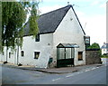
7
A large buttress
The Tan House pub has an unusual appearance. It is said to be so named because in 1715 a tanner by the name of G. Thomas lived there. Its use as a pub seems to have fallen on hard times of late.
Image: © Neil Owen
Taken: 13 Jun 2023
0.09 miles
8
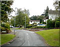
Clearview, Shirenewton
Clearview is a cul-de-sac of 23 detached houses.
Image: © Jaggery
Taken: 14 Jul 2011
0.12 miles
9
The Old Rectory, Shirenewton
The Old Rectory was formerly a coaching inn named the King's Head. It later was in use as a rectory until the 1970s.
Image: © Jaggery
Taken: 14 Jul 2011
0.18 miles
10
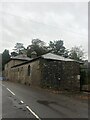
Stables, Coach house and attached boundary walls at Shirenewton Hall
A long range of buildings, backing onto the Crick road with a two storey coach house to the centre, flanked by single storey stable ranges. Listed Grade II. They have been converted into housing.
Image: © Eirian Evans
Taken: 24 Oct 2021
0.18 miles