IMAGES TAKEN NEAR TO
Fordwich Close, CHEPSTOW, NP16 6EL
Introduction
This page details the photographs taken nearby to Fordwich Close, NP16 6EL by members of the Geograph project.
The Geograph project started in 2005 with the aim of publishing, organising and preserving representative images for every square kilometre of Great Britain, Ireland and the Isle of Man.

There are currently over 7.5m images from over14,400 individuals and you can help contribute to the project by visiting https://www.geograph.org.uk
Image Map
Images are licensed for reuse under creativecommons.org/licenses/by-sa/2.0
Notes
- Clicking on the map will re-center to the selected point.
- The higher the marker number, the further away the image location is from the centre of the postcode.
Image Listing (100 Images Found)
Images are licensed for reuse under creativecommons.org/licenses/by-sa/2.0
Image
Details
Distance
1
Fordwich Close, St Arvans
From the A466, Fordwich Close leads to Manor View.
Image: © Jaggery
Taken: 11 Nov 2016
0.03 miles
2
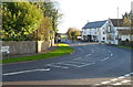
Bend in the A466, St Arvans
Viewed from Devauden Road. Turn left for Monmouth (14 miles, via Tintern) or right for Chepstow.
On the right are Ride & Stride http://www.geograph.org.uk/photo/2710738 and The Piercefield country pub. http://www.geograph.org.uk/photo/2710488
Image: © Jaggery
Taken: 27 Nov 2011
0.03 miles
3
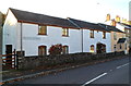
Fountain Cottages, St Arvans
Located at the southern end of Devauden Road, opposite a late Victorian drinking fountain. http://www.geograph.org.uk/photo/2710888
Image: © Jaggery
Taken: 27 Nov 2011
0.03 miles
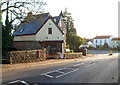
4
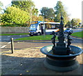
St Arvans Victorian drinking fountain
Located on the corner of Fordwich Close and Devauden Road, opposite the A466. A plaque records:
"In the early 1890's Monmouthshire County Council decided to install drinking fountains throughout the county. Due to the natural beauty of this area local residents raised £30 to purchase a special fountain. This was manufactured by the Sun Foundry in Glasgow. It was assembled in the Iron Stores in Chepstow and opened in 1893. Originally drinking water was obtained by pressing taps at the base of the cherubs which delivered water through the urns held by cherubs.
Villagers supported by grants renovated the fountain as a celebration of the new millennium. It is now a true working example of a Victorian fountain.
This plaque is a memorial to Marsden Lloyd (1927-2002) who was a member of the team that enabled the restoration".
Behind the fountain is a Stagecoach bus on route 69 from Chepstow to Monmouth.
Image: © Jaggery
Taken: 27 Nov 2011
0.03 miles
5
Ride & Stride, St Arvans
Saddlery and outdoor clothing shop alongside the A466, next to the Piercefield country pub. http://www.geograph.org.uk/photo/2710488
Image: © Jaggery
Taken: 27 Nov 2011
0.03 miles
6
Parkfield B&B, St Arvans
Bed and breakfast accommodation located next door to the village shop http://www.geograph.org.uk/photo/2710562 alongside the A466 on the eastern side of the village.
Image: © Jaggery
Taken: 27 Nov 2011
0.03 miles
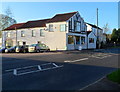
7
Village shop, St Arvans
Located alongside the A466, on the eastern side of the village.
Image: © Jaggery
Taken: 27 Nov 2011
0.03 miles
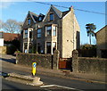
8
St Arvans houses
Houses on the corner of the A466 and Fordwich Close. The edge of a late Victorian drinking fountain http://www.geograph.org.uk/photo/2710888 is at the lower right edge of the view.
Image: © Jaggery
Taken: 27 Nov 2011
0.03 miles
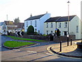
9
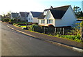
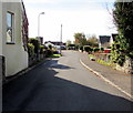
Fordwich Close, St Arvans
Houses on the north side of a cul-de-sac, viewed from the A466 end.
Image: © Jaggery
Taken: 27 Nov 2011
0.04 miles
10
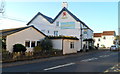
The Piercefield, St Arvans viewed from the south
Owned by S.A. Brain & Company,the Piercefield is a country pub with dining in the village of St Arvans north of Chepstow. Viewed across the A466.
http://www.geograph.org.uk/photo/2710488 to a view from another angle.
Image: © Jaggery
Taken: 27 Nov 2011
0.05 miles