IMAGES TAKEN NEAR TO
Manor View, CHEPSTOW, NP16 6DY
Introduction
This page details the photographs taken nearby to Manor View, NP16 6DY by members of the Geograph project.
The Geograph project started in 2005 with the aim of publishing, organising and preserving representative images for every square kilometre of Great Britain, Ireland and the Isle of Man.

There are currently over 7.5m images from over14,400 individuals and you can help contribute to the project by visiting https://www.geograph.org.uk
Image Map
Images are licensed for reuse under creativecommons.org/licenses/by-sa/2.0
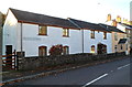
Notes
- Clicking on the map will re-center to the selected point.
- The higher the marker number, the further away the image location is from the centre of the postcode.
Image Listing (97 Images Found)
Images are licensed for reuse under creativecommons.org/licenses/by-sa/2.0
Image
Details
Distance
2
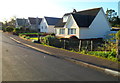
Fordwich Close, St Arvans
Houses on the north side of a cul-de-sac, viewed from the A466 end.
Image: © Jaggery
Taken: 27 Nov 2011
0.06 miles
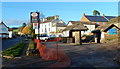
3
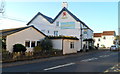
The Piercefield, St Arvans viewed from the south
Owned by S.A. Brain & Company,the Piercefield is a country pub with dining in the village of St Arvans north of Chepstow. Viewed across the A466.
http://www.geograph.org.uk/photo/2710488 to a view from another angle.
Image: © Jaggery
Taken: 27 Nov 2011
0.07 miles
4
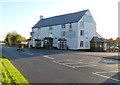
The Piercefield, St Arvans viewed from the north
Viewed across the A466. Owned by S.A. Brain & Company,the Piercefield is a country pub with dining in the village of St Arvans north of Chepstow.
http://www.geograph.org.uk/photo/2710466 to a view from a different angle.
Image: © Jaggery
Taken: 27 Nov 2011
0.07 miles
5
Former Parva Prestige Cars site, St Arvans
Looking along the A466 towards The Piercefield country pub on the left edge of the view. http://www.geograph.org.uk/photo/2710488
Parva's site is now in Grange Mill, Raglan. A banner on the structure in the middle of the view states that St John's-on-the-Hill St Arvans nursery will be opening here soon.
Image: © Jaggery
Taken: 27 Nov 2011
0.07 miles
6

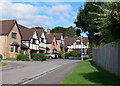
Wyndcliffe View, St Arvans
Cul-de-sac viewed from Church Lane.
Image: © Jaggery
Taken: 11 Nov 2016
0.07 miles
7
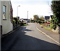
Fordwich Close, St Arvans
From the A466, Fordwich Close leads to Manor View.
Image: © Jaggery
Taken: 11 Nov 2016
0.09 miles
8
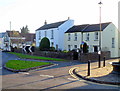
St Arvans houses
Houses on the corner of the A466 and Fordwich Close. The edge of a late Victorian drinking fountain http://www.geograph.org.uk/photo/2710888 is at the lower right edge of the view.
Image: © Jaggery
Taken: 27 Nov 2011
0.09 miles
9
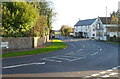
Bend in the A466, St Arvans
Viewed from Devauden Road. Turn left for Monmouth (14 miles, via Tintern) or right for Chepstow.
On the right are Ride & Stride http://www.geograph.org.uk/photo/2710738 and The Piercefield country pub. http://www.geograph.org.uk/photo/2710488
Image: © Jaggery
Taken: 27 Nov 2011
0.09 miles
10
Fountain Cottages, St Arvans
Located at the southern end of Devauden Road, opposite a late Victorian drinking fountain. http://www.geograph.org.uk/photo/2710888
Image: © Jaggery
Taken: 27 Nov 2011
0.09 miles