IMAGES TAKEN NEAR TO
Itton, CHEPSTOW, NP16 6BP
Introduction
This page details the photographs taken nearby to NP16 6BP by members of the Geograph project.
The Geograph project started in 2005 with the aim of publishing, organising and preserving representative images for every square kilometre of Great Britain, Ireland and the Isle of Man.

There are currently over 7.5m images from over14,400 individuals and you can help contribute to the project by visiting https://www.geograph.org.uk
Image Map
Images are licensed for reuse under creativecommons.org/licenses/by-sa/2.0
Notes
- Clicking on the map will re-center to the selected point.
- The higher the marker number, the further away the image location is from the centre of the postcode.
Image Listing (6 Images Found)
Images are licensed for reuse under creativecommons.org/licenses/by-sa/2.0
Image
Details
Distance
1
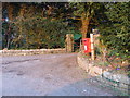
Post box at the entrance to Itton Court
Image: © Ruth Sharville
Taken: 14 Apr 2010
0.03 miles
2
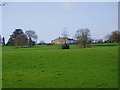
Itton Court, near Chepstow
Set in vast parklands, Itton Court dates back to the 13th century, but was razed to the ground in the 18th century and a Queen Anne mansion built in its place.
Image: © Eirian Evans
Taken: 27 Nov 2006
0.13 miles
3
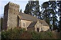
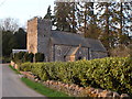
St Deiniol's Church, Itton
Churches and chapels (no 16). Yet another photo! The parish church dates in part from the 14th century although it was mostly rebuilt in 1869.
Image: © Andy Stott
Taken: 1 Jun 2012
0.14 miles
4
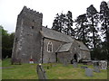
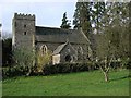
St Deiniol's church, Itton
This photo was taken at 7.30pm of an April evening.
Image: © Ruth Sharville
Taken: 14 Apr 2010
0.16 miles
5
Itton (Llanddinol) St Deiniol's Church
http://www.churchcrawler.pwp.blueyonder.co.uk/churchcrawler/gwent.htm
Image: © ChurchCrawler
Taken: 21 Mar 2002
0.19 miles