IMAGES TAKEN NEAR TO
Shirenewton, CHEPSTOW, NP16 6AP
Introduction
This page details the photographs taken nearby to NP16 6AP by members of the Geograph project.
The Geograph project started in 2005 with the aim of publishing, organising and preserving representative images for every square kilometre of Great Britain, Ireland and the Isle of Man.

There are currently over 7.5m images from over14,400 individuals and you can help contribute to the project by visiting https://www.geograph.org.uk
Image Map
Images are licensed for reuse under creativecommons.org/licenses/by-sa/2.0
Notes
- Clicking on the map will re-center to the selected point.
- The higher the marker number, the further away the image location is from the centre of the postcode.
Image Listing (17 Images Found)
Images are licensed for reuse under creativecommons.org/licenses/by-sa/2.0
Image
Details
Distance
1
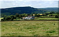
Argoed Farm near Earlswood
Viewed from the Earlswood to Shirenewton road.
Image: © Jaggery
Taken: 14 Jul 2011
0.00 miles
3
Road junction at Argoed Farm, near Shirenewton
Image: © Ruth Sharville
Taken: 9 Nov 2014
0.05 miles
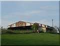
5
Cock-a-Roosting postbox and footpath sign, Earlswood
Located at a junction http://www.geograph.org.uk/photo/2506785 on the road from Earlswood to Shirenewton. The sign points to a footpath descending towards Argoed Farm. Some of the farm buildings can be seen in the middle distance.
Image: © Jaggery
Taken: 14 Jul 2011
0.13 miles
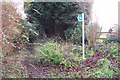
6
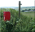
Cock-a-Roosting postbox, Earlswood
Its base hidden by vegetation, a red postbox http://www.geograph.org.uk/photo/2506830 is at the side of the road into Earlswood, opposite Cock-a-Roosting. http://www.geograph.org.uk/photo/2506785
Image: © Jaggery
Taken: 14 Jul 2011
0.13 miles
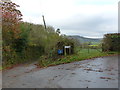
7
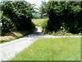
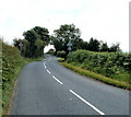
Road to Argoed Farm and Oxpool
The road heads away from a grass triangle http://www.geograph.org.uk/photo/3179079 at the junction with the Earlswood to Shirenewton road.
Image: © Jaggery
Taken: 14 Jul 2011
0.15 miles
8
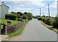
Road to Shirenewton passes Myrtle Cottage, Earlswood
Earlswood is a small rural community with houses mostly without immediate neighbours. The road to Shirenewton passes Myrtle Cottage. http://www.geograph.org.uk/photo/2506728
Image: © Jaggery
Taken: 14 Jul 2011
0.16 miles
9
Road to Shirenewton heads away from Cock-a-Roosting, Earlswood
Behind the camera is a road junction at Cock-a-Roosting. http://www.geograph.org.uk/photo/2506785
Image: © Jaggery
Taken: 14 Jul 2011
0.17 miles
10
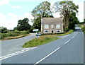
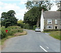
Cock-a-Roosting, Earlswood
Cock-a-Roosting is a detached house at a road junction. The signposts show
Usk, ahead on the right (9 miles).
Central Earlswood, ahead on the left (1 mile).
Behind the camera, Shirenewton (1 mile) and Chepstow (5 miles).
The date stone on the house shows AD 1896.
Image: © Jaggery
Taken: 14 Jul 2011
0.18 miles