IMAGES TAKEN NEAR TO
Lower Mynders, CHEPSTOW, NP16 6AL
Introduction
This page details the photographs taken nearby to Lower Mynders, NP16 6AL by members of the Geograph project.
The Geograph project started in 2005 with the aim of publishing, organising and preserving representative images for every square kilometre of Great Britain, Ireland and the Isle of Man.

There are currently over 7.5m images from over14,400 individuals and you can help contribute to the project by visiting https://www.geograph.org.uk
Image Map (Loading...)


Getting Data...Please wait
Leaflet Map data © OpenStreetMap
Images are licensed for reuse under creativecommons.org/licenses/by-sa/2.0
Notes
- Clicking on the map will re-center to the selected point.
- The higher the marker number, the further away the image location is from the centre of the postcode.
Image Listing (19 Images Found)
Images are licensed for reuse under creativecommons.org/licenses/by-sa/2.0
Image
Details
Distance
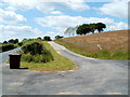
1
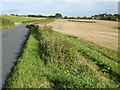
West along Earlswood Road near Shirenewton, Monmouthshire
Ahead for Earlswood. Behind the camera for Shirenewton.
Image: © Jaggery
Taken: 17 Jul 2022
0.01 miles
2
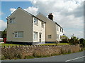
Mynders Cottage, Lower Mynders near Shirenewton
Located alongside the Earlswood to Shirenewton road.
Image: © Jaggery
Taken: 14 Jul 2011
0.01 miles
3
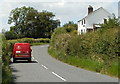
Royal Mail van passes Mynders Cottage near Shirenewton
Heading away from Shirenewton towards Earlswood, the red van passes this cottage. http://www.geograph.org.uk/photo/3179147
Image: © Jaggery
Taken: 14 Jul 2011
0.02 miles
4
Hairpin bend near Shirenewton
Viewed along the access lane to Mynders Cottage. http://www.geograph.org.uk/photo/3179147
The Shirenewton to Earlswood road is on the left.
Image: © Jaggery
Taken: 14 Jul 2011
0.02 miles
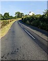
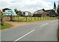
5
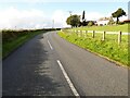
Minor road passing a farm
Minor road passing a farm to the west of the village of Shirenewton.
Image: © Philip Halling
Taken: 27 Sep 2021
0.04 miles
6
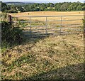
7-bar field gate near Shirenewton
Set back from the south side of Earlswood Road
on the western approach to Shirenewton viewed in July 2022.
Image: © Jaggery
Taken: 17 Jul 2022
0.06 miles
7
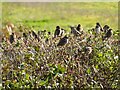
House sparrows
House sparrows (Passer domesticus) on a hedge.
Image: © Philip Halling
Taken: 27 Sep 2021
0.07 miles
8
Mynders Farm near Shirenewton
Viewed from the Earlswood to Shirenewton road.
Image: © Jaggery
Taken: 14 Jul 2011
0.09 miles
9
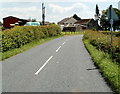
National Cycle Network route 42 near Shirenewton
A small dark blue sign on the post on the right, below a triangular sign, shows that is part of NCR route 42, along the road from Earlswood to Shirenewton, on the approach to Mynders Farm. http://www.geograph.org.uk/photo/3179135
Image: © Jaggery
Taken: 14 Jul 2011
0.12 miles