IMAGES TAKEN NEAR TO
Grasmere Way, CHEPSTOW, NP16 5SS
Introduction
This page details the photographs taken nearby to Grasmere Way, NP16 5SS by members of the Geograph project.
The Geograph project started in 2005 with the aim of publishing, organising and preserving representative images for every square kilometre of Great Britain, Ireland and the Isle of Man.

There are currently over 7.5m images from over14,400 individuals and you can help contribute to the project by visiting https://www.geograph.org.uk
Image Map
Images are licensed for reuse under creativecommons.org/licenses/by-sa/2.0
Notes
- Clicking on the map will re-center to the selected point.
- The higher the marker number, the further away the image location is from the centre of the postcode.
Image Listing (69 Images Found)
Images are licensed for reuse under creativecommons.org/licenses/by-sa/2.0
Image
Details
Distance
1
Chepstow : Bushes & River Wye
Looking across towards the River Wye from a footpath.
Image: © Lewis Clarke
Taken: 14 Feb 2012
0.03 miles
2
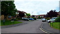
Alice Crescent, Chepstow
Suburbia.
Image: © Jonathan Billinger
Taken: 4 Jun 2012
0.04 miles
3
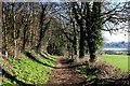
Wales Coast Path, South Chepstow
The long distance footpath heads through a small section of woods as it seeks to enter the town of Chepstow by following as close as possible to the banks of the River Wye
Image: © Chris Heaton
Taken: 11 Feb 2016
0.05 miles
4
Footpath leading down to the River Wye
Right of Way leading off the Wales Coast Path towards the bridge under the railway.
Signs indicate the path is a dead end, and beyond this trespassers will be prosecuted.
Image: © Chris Heaton
Taken: 11 Feb 2016
0.06 miles
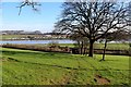
5
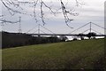
Chepstow : Grassy Field & Wye Bridge
A grassy field with the Wye Bridge in the background.
Image: © Lewis Clarke
Taken: 14 Feb 2012
0.07 miles
6
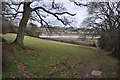
Chepstow : Grassy Field
A grassy field with a path heading down to the River Wye under the railway.
Image: © Lewis Clarke
Taken: 14 Feb 2012
0.07 miles
7
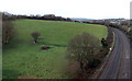
Field at the edge of Bulwark, Chepstow
Viewed from the footpath on the north side of Wye Bridge which carries the M48 motorway.
A sign shows a 50mph speed limit on the railway on the southern approach to Chepstow railway station.
Image: © Jaggery
Taken: 15 Dec 2013
0.10 miles
8
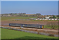
Passenger Train by the River Wye
Train on the shore of the River Wye at Bulwark near Chepstow.
Image: © Wayland Smith
Taken: 17 Mar 2007
0.10 miles
9
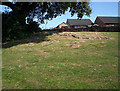
Thornwell Farm Burial Chamber
This sits near The Bulwark not far from Chepstow.The remains of the Neolithic Burial Chamber are in the middle of housing.
Image: © Michael Murray
Taken: 21 Jul 2005
0.10 miles
10
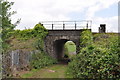
Railway bridge over footpath
Image: © Nick Mutton 01329 000000
Taken: 23 Jul 2010
0.11 miles