IMAGES TAKEN NEAR TO
Oxford Street, CHEPSTOW, NP16 5PQ
Introduction
This page details the photographs taken nearby to Oxford Street, NP16 5PQ by members of the Geograph project.
The Geograph project started in 2005 with the aim of publishing, organising and preserving representative images for every square kilometre of Great Britain, Ireland and the Isle of Man.

There are currently over 7.5m images from over14,400 individuals and you can help contribute to the project by visiting https://www.geograph.org.uk
Image Map
Images are licensed for reuse under creativecommons.org/licenses/by-sa/2.0
Notes
- Clicking on the map will re-center to the selected point.
- The higher the marker number, the further away the image location is from the centre of the postcode.
Image Listing (1094 Images Found)
Images are licensed for reuse under creativecommons.org/licenses/by-sa/2.0
Image
Details
Distance
1

Cymru Kitchens showroom in Chepstow
Occupying a part of the Herbert Lewis department store site, viewed across the A48.
Cymru Kitchens are based in Newport, in the Old Mineral Water Factory, Turner Street. http://www.geograph.org.uk/photo/1976590
Image: © Jaggery
Taken: 7 Jul 2016
0.01 miles
2
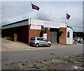
Wye Knot Drive in Chepstow
Wye Knot Drive is a self-drive vehicle hire business at 4 Upper Nelson Street in Chepstow.
Image: © Jaggery
Taken: 7 Jul 2016
0.01 miles
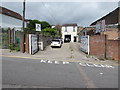
3
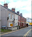
Oxford Street, Chepstow
Viewed from Upper Nelson Street looking towards High Street.
Double yellow lines on both sides of the street indicate no parking at any time
Image: © Jaggery
Taken: 7 Jul 2016
0.01 miles
4
SE corner of the Herbert Lewis department store, Chepstow
This is the Upper Nelson Street and Oxford Street corner of a large department store with a frontage at 9-11 High Street. http://www.geograph.org.uk/photo/545603 The Oxford Street side of the store is 140 metres long.
Herbert Lewis is now one of the oldest department stores in the UK. It was established in 1878 by Herbert Lewis and is still managed by his descendants, now fifth generation. The business has occupied the Coronation Buildings since 1902. They were designed by Herbert Lewis, and named in celebration of the coronation of King Edward VII at Westminster Abbey on August 9th 1902.
Image: © Jaggery
Taken: 13 Nov 2012
0.01 miles
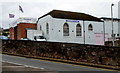
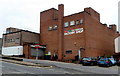
5
Silhouette Dance Club, Chepstow
Located on Upper Nelson Street, alongside Mount Pleasant Road (A48).
Image: © Jaggery
Taken: 8 Sep 2010
0.01 miles
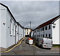
6
Exmouth Place, Chepstow
A row of 7 houses, located between the bottom of School Hill and the A48 (here named Mount Pleasant Road). The far end of Exmouth Place, formerly connecting with the A48, is blocked off, creating a small area used as a car park. A parked car can be seen in front of a yellow lorry.
Image: © Jaggery
Taken: 17 Sep 2010
0.01 miles
7
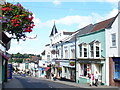
Downtown Chepstow
The main street of the town descends from the Town Gate. It is a colourful scene with many of the historic buildings now painted in pastel shades.
http://www.chepstow.co.uk/Contents/Text/Index.asp?SiteId=137&SiteExtra=14722766&TopNavId=284&NavSideId=1194
Image: © Colin Smith
Taken: 25 Jul 2009
0.02 miles
8
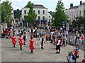
Morris Dancing in Beaufort Square during the Chepstow Festival
Image: © Ruth Sharville
Taken: 3 Jul 2010
0.02 miles
9
Upper Nelson Street side of the Herbert Lewis store in Chepstow
The rear of this https://www.geograph.org.uk/photo/5195486 High Street department store.
Image: © Jaggery
Taken: 7 Jul 2016
0.02 miles
10
Upper Nelson Street side of the former Chepstow Woolworths
Viewed across the A48. Now occupied by The Original Factory Shop, this building was previously a Woolworths store. This is the rear of the shop : the entrance is from High Street. http://www.geograph.org.uk/photo/5190145
Image: © Jaggery
Taken: 13 Nov 2012
0.03 miles