IMAGES TAKEN NEAR TO
Welsh Street, CHEPSTOW, NP16 5LL
Introduction
This page details the photographs taken nearby to Welsh Street, NP16 5LL by members of the Geograph project.
The Geograph project started in 2005 with the aim of publishing, organising and preserving representative images for every square kilometre of Great Britain, Ireland and the Isle of Man.

There are currently over 7.5m images from over14,400 individuals and you can help contribute to the project by visiting https://www.geograph.org.uk
Image Map
Images are licensed for reuse under creativecommons.org/licenses/by-sa/2.0
Notes
- Clicking on the map will re-center to the selected point.
- The higher the marker number, the further away the image location is from the centre of the postcode.
Image Listing (977 Images Found)
Images are licensed for reuse under creativecommons.org/licenses/by-sa/2.0
Image
Details
Distance
1
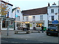
Pye Corner, Chepstow
Square at the top of Bank Street where the White Lion Inn is located.
Image: © Eirian Evans
Taken: 2 Dec 2011
0.01 miles
2
![Chepstow buildings [12]](https://s0.geograph.org.uk/geophotos/06/90/13/6901352_27994608_120x120.jpg)
Chepstow buildings [12]
Number 1 Bank Street is an early 19th century shop with living accommodation building on an early site. Roughcast rendered with a pantile roof. The shopfront is 20th century. Listed, grade II, with details at: https://cadwpublic-api.azurewebsites.net/reports/listedbuilding/FullReport?lang=&id=27090
Chepstow, the most easterly town in Wales, is located on the tidal River Wye, some 3 miles above its confluence with the River Severn. There is evidence of continuous human occupation from the Mesolithic period. The town grew in importance when the Normans erected a castle at what was the lowest bridging point of the River Wye. The town flourished as a port, being exempt from English taxation, and it mainly traded in timber and bark from the Wye Valley. The town became an important centre for tourism from the late eighteenth century.
Image: © Michael Dibb
Taken: 4 Jun 2021
0.01 miles
3
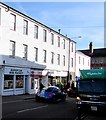
European Mini Market, Chepstow
At 22C Welsh Street, next door to Chepstow Post Office.
A Carlsberg City Dray delivery lorry is on the right.
Image: © Jaggery
Taken: 11 Nov 2016
0.01 miles
4
![Chepstow buildings [13]](https://s2.geograph.org.uk/geophotos/06/90/13/6901362_57cce942_120x120.jpg)
Chepstow buildings [13]
The former White Lion public house is now known simply as The Lion bar. In two ranges at right angles facing onto Pye Corner. Built in the 17th century and greatly altered in the 19th century. The main range, seen here, has rendered walls and a pantile roof with a frosted bar window. The cross wing range Image, has a gable end to the street, rendered walls and a slate roof. Formerly known as Pye Corner and as The Magpie. Listed, grade II, with details at: https://cadwpublic-api.azurewebsites.net/reports/listedbuilding/FullReport?lang=&id=2539
Chepstow, the most easterly town in Wales, is located on the tidal River Wye, some 3 miles above its confluence with the River Severn. There is evidence of continuous human occupation from the Mesolithic period. The town grew in importance when the Normans erected a castle at what was the lowest bridging point of the River Wye. The town flourished as a port, being exempt from English taxation, and it mainly traded in timber and bark from the Wye Valley. The town became an important centre for tourism from the late eighteenth century.
Image: © Michael Dibb
Taken: 4 Jun 2021
0.01 miles
5
![Chepstow buildings [14]](https://s3.geograph.org.uk/geophotos/06/90/13/6901367_ca8d4532_120x120.jpg)
Chepstow buildings [14]
The former White Lion public house is now known simply as The Lion bar. In two ranges at right angles facing onto Pye Corner. Built in the 17th century and greatly altered in the 19th century. The main range Image, has rendered walls and a pantile roof with a frosted bar window. The cross wing range, seen here, has a gable end to the street, rendered walls and a slate roof. Formerly known as Pye Corner and as The Magpie. Listed, grade II, with details at: https://cadwpublic-api.azurewebsites.net/reports/listedbuilding/FullReport?lang=&id=2539
Chepstow, the most easterly town in Wales, is located on the tidal River Wye, some 3 miles above its confluence with the River Severn. There is evidence of continuous human occupation from the Mesolithic period. The town grew in importance when the Normans erected a castle at what was the lowest bridging point of the River Wye. The town flourished as a port, being exempt from English taxation, and it mainly traded in timber and bark from the Wye Valley. The town became an important centre for tourism from the late eighteenth century.
Image: © Michael Dibb
Taken: 4 Jun 2021
0.01 miles
6
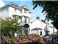
Castle Court
Elegant house in central Chepstow with rear views to the ruined Chepstow Castle.
Image: © Colin Smith
Taken: 25 Jul 2009
0.01 miles
7
![Chepstow buildings [29]](https://s1.geograph.org.uk/geophotos/07/35/63/7356349_b3462ef3_120x120.jpg)
Chepstow buildings [29]
Number 21 Welsh Street is a former house, now shops, offices and flats. Built in the early 19th century on the site of earlier buildings. Constructed of rendered brick, lined to simulate ashlar, under a slate roof. The ground floor has two large 20th century shopfronts. Listed, grade II, with details at: https://cadwpublic-api.azurewebsites.net/reports/listedbuilding/FullReport?lang=&id=2595
A second market cross stood here called Robin Hood's Cross and the junction of Moor Street and Welsh Street was called The Cross into the 19th century, although the cross was dismantled after 1759 by the Chepstow Turnpike Trust.
Chepstow, the most easterly town in Wales, is located on the tidal River Wye, some 3 miles above its confluence with the River Severn. There is evidence of continuous human occupation from the Mesolithic period. The town grew in importance when the Normans erected a castle at what was the lowest bridging point of the River Wye. The town flourished as a port, being exempt from English taxation, and it mainly traded in timber and bark from the Wye Valley. The town became an important centre for tourism from the late eighteenth century.
Image: © Michael Dibb
Taken: 3 Sep 2022
0.01 miles
8
The Art of Fruit & Veg, Chepstow
Greengrocer and delicatessen at 21 Welsh Street.
Image: © Jaggery
Taken: 11 Nov 2016
0.01 miles
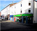
9
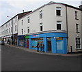
Shop Locally in Chepstow
Shop Locally convenience store at 21 Welsh Street viewed in February 2018.
The Art of Fruit & Veg geengrocer and delicatessen https://www.geograph.org.uk/photo/5196993 was here in November 2016.
Image: © Jaggery
Taken: 19 Feb 2018
0.01 miles
10
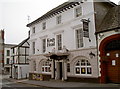
The King's Head
A busy pub right in the middle of town and with some fine details - see Image] for an example.
Image: © Neil Owen
Taken: 7 Aug 2013
0.01 miles