Chepstow buildings [14]
Introduction
The photograph on this page of Chepstow buildings [14] by Michael Dibb as part of the Geograph project.
The Geograph project started in 2005 with the aim of publishing, organising and preserving representative images for every square kilometre of Great Britain, Ireland and the Isle of Man.

There are currently over 7.5m images from over 14,400 individuals and you can help contribute to the project by visiting https://www.geograph.org.uk
Chepstow buildings [14]
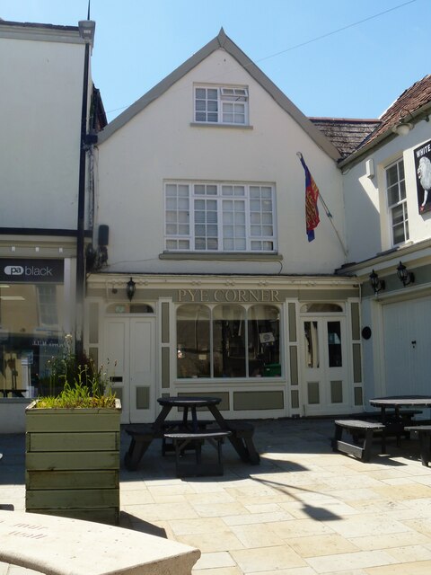
Image: © Michael Dibb Taken: 4 Jun 2021
The former White Lion public house is now known simply as The Lion bar. In two ranges at right angles facing onto Pye Corner. Built in the 17th century and greatly altered in the 19th century. The main range Image, has rendered walls and a pantile roof with a frosted bar window. The cross wing range, seen here, has a gable end to the street, rendered walls and a slate roof. Formerly known as Pye Corner and as The Magpie. Listed, grade II, with details at: https://cadwpublic-api.azurewebsites.net/reports/listedbuilding/FullReport?lang=&id=2539 Chepstow, the most easterly town in Wales, is located on the tidal River Wye, some 3 miles above its confluence with the River Severn. There is evidence of continuous human occupation from the Mesolithic period. The town grew in importance when the Normans erected a castle at what was the lowest bridging point of the River Wye. The town flourished as a port, being exempt from English taxation, and it mainly traded in timber and bark from the Wye Valley. The town became an important centre for tourism from the late eighteenth century.
Images are licensed for reuse under creativecommons.org/licenses/by-sa/2.0
Image Location
Latitude
51.641229
Longitude
-2.67669