IMAGES TAKEN NEAR TO
Dell View, CHEPSTOW, NP16 5JA
Introduction
This page details the photographs taken nearby to Dell View, NP16 5JA by members of the Geograph project.
The Geograph project started in 2005 with the aim of publishing, organising and preserving representative images for every square kilometre of Great Britain, Ireland and the Isle of Man.

There are currently over 7.5m images from over14,400 individuals and you can help contribute to the project by visiting https://www.geograph.org.uk
Image Map
Images are licensed for reuse under creativecommons.org/licenses/by-sa/2.0
Notes
- Clicking on the map will re-center to the selected point.
- The higher the marker number, the further away the image location is from the centre of the postcode.
Image Listing (981 Images Found)
Images are licensed for reuse under creativecommons.org/licenses/by-sa/2.0
Image
Details
Distance

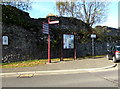
2
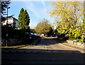
Dell View, Chepstow
Cul-de-sac near Chepstow Library.
Image: © Jaggery
Taken: 11 Nov 2016
0.02 miles
3
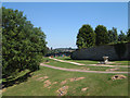
Children's Play Area in The Dell, Chepstow
The gravelled path is an alternative route to the Town Centre.
Image: © Roy Parkhouse
Taken: 18 Jul 2006
0.02 miles
4

Chepstow - The Dell from the Castle
Welsh Street runs across the top of the photograph.
Image: © Roy Parkhouse
Taken: 2 Apr 2005
0.02 miles
5

Chepstow Library
Next to the Welsh Street car park.
http://www.visionwebsites.co.uk/Contents/Text/Index.asp?SiteId=137&SiteExtra=14722766&TopNavId=283&NavSideId=1480
Image: © Roy Parkhouse
Taken: 17 Aug 2007
0.02 miles
6
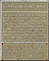
Chepstow - Port Wall plaque
This plaque is attached to the Port Wall adjacent to the entrance to Castle Dell : Image
Image: © Roy Parkhouse
Taken: 3 Sep 2007
0.02 miles
7
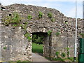
Chepstow - entrance to Castle Dell
From the Welsh Street car park.
Image: © Roy Parkhouse
Taken: 3 Sep 2007
0.02 miles
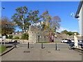
8
Part of the medieval Port Wall, Chepstow
The information notice on the left states that the Port Wall was the medieval defensive wall enclosing the town of Chepstow. It was built by Roger Bigod, lord of Chepstow c1272-1282. Set in a loop of the River Wye, medieval Chepstow had no stone defences before the late 13th century when this wall was built across the neck of the promontory. It was 1,100 metres (1,200 yds) long with ten open-backed semicircular towers, and a gatehouse giving access to the town.
The much-rebuilt town gate http://www.geograph.org.uk/photo/3664795 still stands below Moor Street. Stretches of the wall have disappeared at either end, but its central section is largely intact. The Port Wall is in the care of Cadw.
Image: © Jaggery
Taken: 11 Nov 2016
0.03 miles
9
The Portwall, and car park access, Chepstow
Part of Chepstow library can be seen to the far right of the photo. The historic Portwall has been breached to give access to the car park.
Image: © Ruth Sharville
Taken: 22 Oct 2018
0.03 miles
10

Part of the Wye Valley Walk
Seen here climbing up Castle Dell.
Image: © jeff collins
Taken: 7 Nov 2018
0.03 miles